Gordexola geodata
Gordexola (Basque Country) is a seat of a third-order administrative division; located in Spain in Europe/Madrid (GMT+2) time zone. In our database, there are 6762 cities with bigger population. Compared to other cities in Spain, 96.2% of cities are located further ↓South; 53.2% of cities are located further ←West and 89.2% of cities have higher elevation than Gordexola. Note1


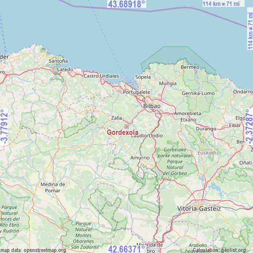
Gordexola GPS coordinates[2]
43° 10' 42.96" North, 3° 4' 33.6" West
| Map corner | latitude | longitude |
|---|---|---|
| Upper-left | 43.68918°, | -3.77912° |
| Center: | 43.1786°, | -3.076° |
| Lower-right: | 42.66371°, | -2.37287° |
| Map W x H: | 114×114 km | = 70.8×70.8mi |
| max Lat: | 43.74134° ⇑3.8% North |
| Gordexola: | 43.1786° |
| min Lat: | ⇓96.2% South 27.64134° |
| min Long | Gordexola | max Long |
| -18.00367° | -3.076° | 4.2899° |
| W 53.2%⇐ | ⇒46.8% E |
Elevation
Elevation of Gordexola is 77 m = 253 ft, and this is 521 m = 1709 ft below average elevation for this country.
| Max E: |
1682 m = 5518 ft | 89.2% |
| Avg. | 598 m = 1962 ft | |
| Gordexola | 77 m = 253 ft | |
Min E: |
0 m = 0 ft | 10.8% |
See also: Spain elevation on elevation.city.
Geographical zone
Gordexola is located in North temperate zone (between Tropic of Cancer and the Arctic Circle). Distance of this Northern Tropic circle is 2195.1 km =1364 mi to South.| Distance of | km | miles | from Gordexola |
|---|---|---|---|
| North Pole | 5206.1 | 3234.9 | to North |
| Arctic Circle | 2600.2 | 1615.7 | to North |
| Tropic Cancer | 2195.1 | 1364 | to South |
| Equator | 4801 | 2983.2 | to South |


Nearby cities:
15 places around Gordexola: (largest is in red/bold)
• Alonsotegi
10.3 km =6.4 mi,  44°
44°
• Amurrio
15.6 km =9.7 mi,  156°
156°
• Avellaneda
9 km =5.6 mi,  309°
309°
• Balmaseda
10.3 km =6.4 mi,  283°
283°
• Barakaldo
14.9 km =9.3 mi,  28°
28°
• Bilbao
15.4 km =9.6 mi,  52°
52°
• Elexalde
12 km =7.5 mi,  105°
105°
• Güeñes
4.1 km =2.5 mi,  337°
337°
• Laudio / Llodio
10 km =6.2 mi, 113°
• Ortuella
14.8 km =9.2 mi,  6°
6°
• San Pedro Galdames
8.2 km =5.1 mi,  346°
346°
• Santutxu
15.4 km =9.6 mi,  57°
57°
• Sestao
15.6 km =9.7 mi,  20°
20°
• Sopuerta
11.3 km =7 mi,  325°
325°
• Zalla
7.7 km =4.8 mi,  322°
322°
Sources, notices
• [Note1] Compared only with cities in Spain existing in our database
• [Src1] Map data: © OpenStreetMap contributors (CC-BY-SA)
• [Src2] Other city data from geonames.org with taken over terms of usage.
• [Src3] Geographical zone / Annual Mean Temperature by Robert A. Rohde @ Wikipedia
