Almorox geodata
Almorox (Castille-La Mancha) is a seat of a third-order administrative division; located in Spain in Europe/Madrid (GMT+2) time zone. With population of 2,319 people, there are 1990 cities with bigger population in this country. Compared to other cities in Spain, 66.7% of cities are located further ↑North; 64.8% of cities are located further →East and 59.1% of cities have higher elevation than Almorox. Note1
Administrative division(s):
- Level 1: Castille-La Mancha
- Level 2: Province of Toledo
- Level 3: Almorox


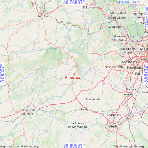
Almorox GPS coordinates[2]
40° 14' 3.228" North, 4° 23' 25.584" West
| Map corner | latitude | longitude |
|---|---|---|
| Upper-left | 40.76887°, | -5.09357° |
| Center: | 40.23423°, | -4.39044° |
| Lower-right: | 39.69533°, | -3.68732° |
| Map W x H: | 119.4×119.4 km | = 74.2×74.2mi |
| max Lat: | 43.74134° ⇑66.7% North |
| Almorox: | 40.23423° |
| min Lat: | ⇓33.3% South 27.64134° |
| min Long | Almorox | max Long |
| -18.00367° | -4.39044° | 4.2899° |
| W 35.2%⇐ | ⇒64.8% E |
Elevation
Elevation of Almorox is 539 m = 1768 ft, and this is 59 m = 194 ft below average elevation for this country.
| Max E: |
1682 m = 5518 ft | 59.1% |
| Avg. | 598 m = 1962 ft | |
| Almorox | 539 m = 1768 ft | |
Min E: |
0 m = 0 ft | 40.9% |
See also: Spain elevation on elevation.city.
Geographical zone
Almorox is located in North temperate zone (between Tropic of Cancer and the Arctic Circle). Distance of this Northern Tropic circle is 1867.7 km =1160.5 mi to South.| Distance of | km | miles | from Almorox |
|---|---|---|---|
| North Pole | 5533.4 | 3438.3 | to North |
| Arctic Circle | 2927.5 | 1819.1 | to North |
| Tropic Cancer | 1867.7 | 1160.5 | to South |
| Equator | 4473.6 | 2779.8 | to South |


Nearby cities:
15 places around Almorox: (largest is in red/bold)
• Cadalso de los Vidrios
8.2 km =5.1 mi,  333°
333°
• Cenicientos
7.3 km =4.5 mi,  297°
297°
• Escalona
7.6 km =4.7 mi,  189°
189°
• Hormigos
15.9 km =9.9 mi,  196°
196°
• La Torre de Esteban Hambrán
16.5 km =10.3 mi,  115°
115°
• Méntrida
16.7 km =10.4 mi,  88°
88°
• Navahondilla
13.5 km =8.4 mi,  318°
318°
• Nombela
12.9 km =8 mi,  227°
227°
• Paredes de Escalona
4.7 km =2.9 mi, 226°
• Pelayos de la Presa
14.8 km =9.2 mi,  18°
18°
• Quismondo
15.4 km =9.6 mi,  158°
158°
• Rozas de Puerto Real
12.1 km =7.5 mi, 319°
• San Martín de Valdeiglesias
14.2 km =8.8 mi,  357°
357°
• Sotillo de la Adrada
17.6 km =10.9 mi,  291°
291°
• Villa del Prado
8.7 km =5.4 mi,  55°
55°
Sources, notices
• [Note1] Compared only with cities in Spain existing in our database
• [Src1] Map data: © OpenStreetMap contributors (CC-BY-SA)
• [Src2] Other city data from geonames.org with taken over terms of usage.
• [Src3] Geographical zone / Annual Mean Temperature by Robert A. Rohde @ Wikipedia
