Cuarte de Huerva geodata
Cuarte de Huerva (Aragon) is a seat of a third-order administrative division; located in Spain in Europe/Madrid (GMT+2) time zone. With population of 2,913 people, there are 1752 cities with bigger population in this country. Compared to other cities in Spain, 63.3% of cities are located further ↓South; 77.7% of cities are located further ←West and 77.6% of cities have higher elevation than Cuarte de Huerva. Note1
Administrative division(s):
- Level 1: Aragon
- Level 2: Provincia de Zaragoza
- Level 3: Cuarte de Huerva


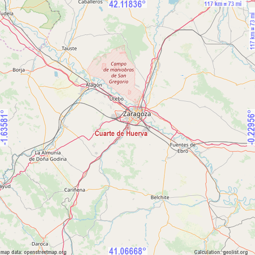
Cuarte de Huerva GPS coordinates[2]
41° 35' 40.776" North, 0° 55' 57.648" West
| Map corner | latitude | longitude |
|---|---|---|
| Upper-left | 42.11836°, | -1.63581° |
| Center: | 41.59466°, | -0.93268° |
| Lower-right: | 41.06668°, | -0.22956° |
| Map W x H: | 116.9×116.9 km | = 72.6×72.6mi |
| max Lat: | 43.74134° ⇑36.7% North |
| Cuarte de Huerva: | 41.59466° |
| min Lat: | ⇓63.3% South 27.64134° |
| min Long | Cuarte de Huerv | max Long |
| -18.00367° | -0.93268° | 4.2899° |
| W 77.7%⇐ | ⇒22.3% E |
Elevation
Elevation of Cuarte de Huerva is 262 m = 860 ft, and this is 336 m = 1102 ft below average elevation for this country.
| Max E: |
1682 m = 5518 ft | 77.6% |
| Avg. | 598 m = 1962 ft | |
| Cuarte de Huerva | 262 m = 860 ft | |
Min E: |
0 m = 0 ft | 22.4% |
See also: Spain elevation on elevation.city.
Geographical zone
Cuarte de Huerva is located in North temperate zone (between Tropic of Cancer and the Arctic Circle). Distance of this Northern Tropic circle is 2019 km =1254.5 mi to South.| Distance of | km | miles | from Cuarte de Huerva |
|---|---|---|---|
| North Pole | 5382.2 | 3344.3 | to North |
| Arctic Circle | 2776.3 | 1725.1 | to North |
| Tropic Cancer | 2019 | 1254.5 | to South |
| Equator | 4624.9 | 2873.8 | to South |


Nearby cities:
15 places around Cuarte de Huerva: (largest is in red/bold)
• Almozara
7.8 km =4.8 mi,  19°
19°
• Botorrita
12.7 km =7.9 mi,  220°
220°
• Cadrete
4.9 km =3 mi,  207°
207°
• Delicias
6.4 km =4 mi, 18°
• El Burgo de Ebro
16.1 km =10 mi,  99°
99°
• Jaulín
16.6 km =10.3 mi,  197°
197°
• María de Huerva
8.2 km =5.1 mi, 220°
• Montecanal
3.9 km =2.4 mi,  352°
352°
• Mozota
16.7 km =10.4 mi, 222°
• Oliver-Valdefierro
5.5 km =3.4 mi,  359°
359°
• Puebla de Alfindén
15.6 km =9.7 mi,  74°
74°
• Utebo
13.8 km =8.6 mi,  336°
336°
• Valmadrid
17.3 km =10.7 mi,  166°
166°
• Villamayor de Gállego
16.7 km =10.4 mi,  52°
52°
• Zaragoza
8.2 km =5.1 mi,  33°
33°
Sources, notices
• [Note1] Compared only with cities in Spain existing in our database
• [Src1] Map data: © OpenStreetMap contributors (CC-BY-SA)
• [Src2] Other city data from geonames.org with taken over terms of usage.
• [Src3] Geographical zone / Annual Mean Temperature by Robert A. Rohde @ Wikipedia
