Villoruela geodata
Villoruela (Castille and León) is a seat of a third-order administrative division; located in Spain in Europe/Madrid (GMT+2) time zone. With population of 983 people, there are 2974 cities with bigger population in this country. Compared to other cities in Spain, 51.3% of cities are located further ↑North; 77.3% of cities are located further →East and 72.1% of cities have lower elevation than Villoruela. Note1
Administrative division(s):
- Level 1: Castille and León
- Level 2: Provincia de Salamanca
- Level 3: Villoruela


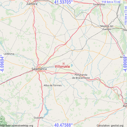
Villoruela GPS coordinates[2]
41° 0' 30.96" North, 5° 23' 37.716" West
| Map corner | latitude | longitude |
|---|---|---|
| Upper-left | 41.53705°, | -6.09694° |
| Center: | 41.0086°, | -5.39381° |
| Lower-right: | 40.47588°, | -4.69069° |
| Map W x H: | 118×118 km | = 73.3×73.3mi |
| max Lat: | 43.74134° ⇑51.3% North |
| Villoruela: | 41.0086° |
| min Lat: | ⇓48.7% South 27.64134° |
| min Long | Villoruela | max Long |
| -18.00367° | -5.39381° | 4.2899° |
| W 22.7%⇐ | ⇒77.3% E |
Elevation
Elevation of Villoruela is 828 m = 2717 ft, and this is 230 m = 755 ft above average elevation for this country.
| Max E: |
1682 m = 5518 ft | 27.9% |
| Villoruela | 828 m 2717 ft | |
| Avg. | 598 m = 1962 ft | |
Min E: |
0 m = 0 ft | 72.1% |
See also: Spain elevation on elevation.city.
Geographical zone
Villoruela is located in North temperate zone (between Tropic of Cancer and the Arctic Circle). Distance of this Northern Tropic circle is 1953.8 km =1214 mi to South.| Distance of | km | miles | from Villoruela |
|---|---|---|---|
| North Pole | 5447.3 | 3384.8 | to North |
| Arctic Circle | 2841.4 | 1765.6 | to North |
| Tropic Cancer | 1953.8 | 1214 | to South |
| Equator | 4559.7 | 2833.3 | to South |


Nearby cities:
15 places around Villoruela: (largest is in red/bold)
• Alconada
11.2 km =7 mi,  166°
166°
• Aldearrubia
8.8 km =5.5 mi,  269°
269°
• Babilafuente
4.4 km =2.7 mi,  217°
217°
• Cabezabellosa de la Calzada
8.9 km =5.5 mi,  296°
296°
• Cantalpino
7.3 km =4.5 mi,  46°
46°
• Cordovilla
6.5 km =4 mi,  189°
189°
• Encinas de Abajo
10.4 km =6.5 mi, 218°
• Espino de la Orbada
11.2 km =7 mi,  346°
346°
• Huerta
7.6 km =4.7 mi,  234°
234°
• Pitiegua
8.5 km =5.3 mi,  314°
314°
• Poveda de las Cintas
12 km =7.5 mi,  69°
69°
• San Morales
9.3 km =5.8 mi,  259°
259°
• Ventosa del Río Almar
9.8 km =6.1 mi,  157°
157°
• Villar de Gallimazo
10.8 km =6.7 mi,  124°
124°
• Villoría
2.3 km =1.4 mi,  133°
133°
Sources, notices
• [Note1] Compared only with cities in Spain existing in our database
• [Src1] Map data: © OpenStreetMap contributors (CC-BY-SA)
• [Src2] Other city data from geonames.org with taken over terms of usage.
• [Src3] Geographical zone / Annual Mean Temperature by Robert A. Rohde @ Wikipedia
