Huete geodata
Huete (Castille-La Mancha) is a seat of a third-order administrative division; located in Spain in Europe/Madrid (GMT+1) time zone. With population of 2,075 people, there are 2114 cities with bigger population in this country. Compared to other cities in Spain, 68% of cities are located further ↑North; 58.7% of cities are located further ←West and 71.8% of cities have lower elevation than Huete. Note1


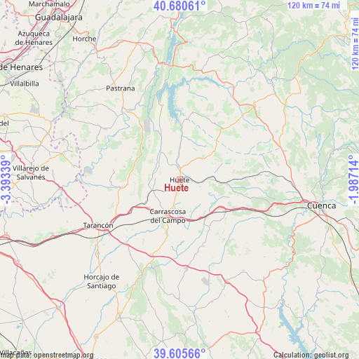
Huete GPS coordinates[2]
40° 8' 42.936" North, 2° 41' 24.936" West
| Map corner | latitude | longitude |
|---|---|---|
| Upper-left | 40.68061°, | -3.39339° |
| Center: | 40.14526°, | -2.69026° |
| Lower-right: | 39.60566°, | -1.98714° |
| Map W x H: | 119.5×119.5 km | = 74.3×74.3mi |
| max Lat: | 43.74134° ⇑68% North |
| Huete: | 40.14526° |
| min Lat: | ⇓32% South 27.64134° |
| min Long | Huete | max Long |
| -18.00367° | -2.69026° | 4.2899° |
| W 58.7%⇐ | ⇒41.3% E |
Elevation
Elevation of Huete is 826 m = 2710 ft, and this is 228 m = 748 ft above average elevation for this country.
| Max E: |
1682 m = 5518 ft | 28.2% |
| Huete | 826 m 2710 ft | |
| Avg. | 598 m = 1962 ft | |
Min E: |
0 m = 0 ft | 71.8% |
See also: Spain elevation on elevation.city.
Geographical zone
Huete is located in North temperate zone (between Tropic of Cancer and the Arctic Circle). Distance of this Northern Tropic circle is 1857.8 km =1154.4 mi to South.| Distance of | km | miles | from Huete |
|---|---|---|---|
| North Pole | 5543.3 | 3444.4 | to North |
| Arctic Circle | 2937.4 | 1825.2 | to North |
| Tropic Cancer | 1857.8 | 1154.4 | to South |
| Equator | 4463.7 | 2773.6 | to South |


Nearby cities:
15 places around Huete: (largest is in red/bold)
• Albalate de Zorita
22.3 km =13.9 mi,  324°
324°
• Alcázar del Rey
13.6 km =8.5 mi,  227°
227°
• Barajas de Melo
19.4 km =12.1 mi,  262°
262°
• Gascueña
22.5 km =14 mi,  40°
40°
• Huelves
20.1 km =12.5 mi,  235°
235°
• Illana
19.1 km =11.9 mi,  283°
283°
• Leganiel
22.2 km =13.8 mi, 275°
• Paredes
16.5 km =10.3 mi, 237°
• Pineda de Gigüela
14.1 km =8.8 mi,  118°
118°
• Rozalén del Monte
19.8 km =12.3 mi,  209°
209°
• Saceda-Trasierra
13.9 km =8.6 mi,  274°
274°
• Tinajas
22 km =13.7 mi,  24°
24°
• Torrejoncillo del Rey
18.3 km =11.4 mi,  146°
146°
• Vellisca
10.7 km =6.6 mi, 260°
• Villalba del Rey
22.8 km =14.2 mi,  10°
10°
Sources, notices
• [Note1] Compared only with cities in Spain existing in our database
• [Src1] Map data: © OpenStreetMap contributors (CC-BY-SA)
• [Src2] Other city data from geonames.org with taken over terms of usage.
• [Src3] Geographical zone / Annual Mean Temperature by Robert A. Rohde @ Wikipedia
