Albendea geodata
Albendea (Castille-La Mancha) is a seat of a third-order administrative division; located in Spain in Europe/Madrid (GMT+2) time zone. With population of 160 people, there are 5341 cities with bigger population in this country. Compared to other cities in Spain, 62.1% of cities are located further ↑North; 62% of cities are located further ←West and 73.4% of cities have lower elevation than Albendea. Note1
Administrative division(s):
- Level 1: Castille-La Mancha
- Level 2: Provincia de Cuenca
- Level 3: Albendea


Albendea GPS coordinates[2]
40° 29' 15.036" North, 2° 25' 2.892" West
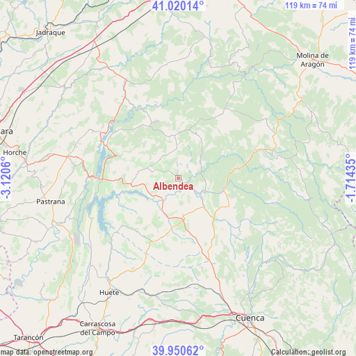
| Map corner | latitude | longitude |
|---|---|---|
| Upper-left | 41.02014°, | -3.1206° |
| Center: | 40.48751°, | -2.41747° |
| Lower-right: | 39.95062°, | -1.71435° |
| Map W x H: | 118.9×118.9 km | = 73.9×73.9mi |
| max Lat: | 43.74134° ⇑62.1% North |
| Albendea: | 40.48751° |
| min Lat: | ⇓37.9% South 27.64134° |
| min Long | Albendea | max Long |
| -18.00367° | -2.41747° | 4.2899° |
| W 62%⇐ | ⇒38% E |
Elevation
Elevation of Albendea is 838 m = 2749 ft, and this is 240 m = 787 ft above average elevation for this country.
| Max E: |
1682 m = 5518 ft | 26.6% |
| Albendea | 838 m 2749 ft | |
| Avg. | 598 m = 1962 ft | |
Min E: |
0 m = 0 ft | 73.4% |
See also: Spain elevation on elevation.city.
Geographical zone
Albendea is located in North temperate zone (between Tropic of Cancer and the Arctic Circle). Distance of this Northern Tropic circle is 1895.9 km =1178.1 mi to South.| Distance of | km | miles | from Albendea |
|---|---|---|---|
| North Pole | 5505.3 | 3420.8 | to North |
| Arctic Circle | 2899.4 | 1801.6 | to North |
| Tropic Cancer | 1895.9 | 1178.1 | to South |
| Equator | 4501.8 | 2797.3 | to South |


Nearby cities:
15 places around Albendea: (largest is in red/bold)
• Alcantud
9.8 km =6.1 mi,  46°
46°
• Arandilla del Arroyo
3.8 km =2.4 mi, 48°
• Canalejas del Arroyo
14.7 km =9.1 mi,  206°
206°
• Castilforte
7.9 km =4.9 mi,  350°
350°
• Cañaveras
14.3 km =8.9 mi,  172°
172°
• Escamilla
14.1 km =8.8 mi,  299°
299°
• Millana
13.2 km =8.2 mi,  279°
279°
• Peralveche
14 km =8.7 mi, 348°
• Priego
9.7 km =6 mi,  115°
115°
• Salmerón
9.1 km =5.7 mi,  315°
315°
• San Pedro Palmiches
6.5 km =4 mi, 171°
• Valdeolivas
3.1 km =1.9 mi,  311°
311°
• Villaconejos de Trabaque
12.7 km =7.9 mi,  139°
139°
• Villar del Infantado
6.3 km =3.9 mi,  235°
235°
• Vindel
11.5 km =7.1 mi,  15°
15°
Sources, notices
• [Note1] Compared only with cities in Spain existing in our database
• [Src1] Map data: © OpenStreetMap contributors (CC-BY-SA)
• [Src2] Other city data from geonames.org with taken over terms of usage.
• [Src3] Geographical zone / Annual Mean Temperature by Robert A. Rohde @ Wikipedia
