Salmerón geodata
Salmerón (Castille-La Mancha) is a seat of a third-order administrative division; located in Spain in Europe/Madrid (GMT+2) time zone. With population of 217 people, there are 4938 cities with bigger population in this country. Compared to other cities in Spain, 60.9% of cities are located further ↑North; 61% of cities are located further ←West and 72.6% of cities have lower elevation than Salmerón. Note1
Administrative division(s):
- Level 1: Castille-La Mancha
- Level 2: Provincia de Guadalajara
- Level 3: Salmerón


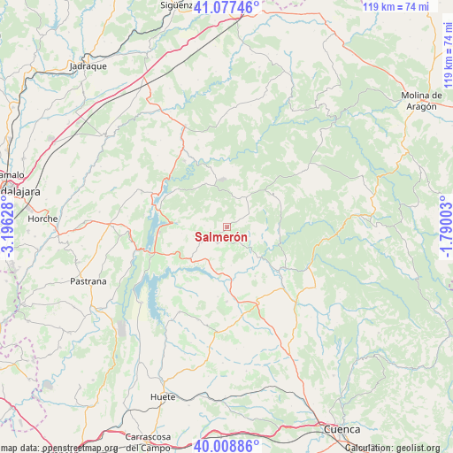
Salmerón GPS coordinates[2]
40° 32' 43.044" North, 2° 29' 35.34" West
| Map corner | latitude | longitude |
|---|---|---|
| Upper-left | 41.07746°, | -3.19628° |
| Center: | 40.54529°, | -2.49315° |
| Lower-right: | 40.00886°, | -1.79003° |
| Map W x H: | 118.8×118.8 km | = 73.8×73.8mi |
| max Lat: | 43.74134° ⇑60.9% North |
| Salmerón: | 40.54529° |
| min Lat: | ⇓39.1% South 27.64134° |
| min Long | Salmerón | max Long |
| -18.00367° | -2.49315° | 4.2899° |
| W 61%⇐ | ⇒39% E |
Elevation
Elevation of Salmerón is 831 m = 2726 ft, and this is 233 m = 764 ft above average elevation for this country.
| Max E: |
1682 m = 5518 ft | 27.4% |
| Salmerón | 831 m 2726 ft | |
| Avg. | 598 m = 1962 ft | |
Min E: |
0 m = 0 ft | 72.6% |
See also: Spain elevation on elevation.city.
Geographical zone
Salmerón is located in North temperate zone (between Tropic of Cancer and the Arctic Circle). Distance of this Northern Tropic circle is 1902.3 km =1182 mi to South.| Distance of | km | miles | from Salmerón |
|---|---|---|---|
| North Pole | 5498.8 | 3416.8 | to North |
| Arctic Circle | 2893 | 1797.6 | to North |
| Tropic Cancer | 1902.3 | 1182 | to South |
| Equator | 4508.2 | 2801.3 | to South |


Nearby cities:
15 places around Salmerón: (largest is in red/bold)
• Albendea
9.1 km =5.7 mi,  135°
135°
• Alcantud
13.6 km =8.5 mi,  88°
88°
• Alcocer
12.9 km =8 mi,  229°
229°
• Alique
13.6 km =8.5 mi,  289°
289°
• Arandilla del Arroyo
10 km =6.2 mi,  112°
112°
• Arbeteta
15.8 km =9.8 mi,  28°
28°
• Castilforte
5.3 km =3.3 mi,  75°
75°
• Escamilla
5.9 km =3.7 mi,  274°
274°
• Millana
7.8 km =4.8 mi,  237°
237°
• Pareja
13.2 km =8.2 mi,  275°
275°
• Peralveche
8.2 km =5.1 mi, 26°
• San Pedro Palmiches
14.8 km =9.2 mi,  150°
150°
• Valdeolivas
6 km =3.7 mi, 137°
• Villar del Infantado
10.1 km =6.3 mi,  173°
173°
• Vindel
10.6 km =6.6 mi,  63°
63°
Sources, notices
• [Note1] Compared only with cities in Spain existing in our database
• [Src1] Map data: © OpenStreetMap contributors (CC-BY-SA)
• [Src2] Other city data from geonames.org with taken over terms of usage.
• [Src3] Geographical zone / Annual Mean Temperature by Robert A. Rohde @ Wikipedia
