Valdeolivas geodata
Valdeolivas (Castille-La Mancha) is a seat of a third-order administrative division; located in Spain in Europe/Madrid (GMT+2) time zone. With population of 268 people, there are 4645 cities with bigger population in this country. Compared to other cities in Spain, 61.7% of cities are located further ↑North; 61.6% of cities are located further ←West and 83.1% of cities have lower elevation than Valdeolivas. Note1
Administrative division(s):
- Level 1: Castille-La Mancha
- Level 2: Provincia de Cuenca
- Level 3: Valdeolivas


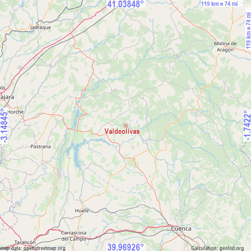
Valdeolivas GPS coordinates[2]
40° 30' 21.6" North, 2° 26' 43.152" West
| Map corner | latitude | longitude |
|---|---|---|
| Upper-left | 41.03848°, | -3.14845° |
| Center: | 40.506°, | -2.44532° |
| Lower-right: | 39.96926°, | -1.7422° |
| Map W x H: | 118.9×118.9 km | = 73.9×73.9mi |
| max Lat: | 43.74134° ⇑61.7% North |
| Valdeolivas: | 40.506° |
| min Lat: | ⇓38.3% South 27.64134° |
| min Long | Valdeolivas | max Long |
| -18.00367° | -2.44532° | 4.2899° |
| W 61.6%⇐ | ⇒38.4% E |
Elevation
Elevation of Valdeolivas is 929 m = 3048 ft, and this is 331 m = 1086 ft above average elevation for this country.
| Max E: |
1682 m = 5518 ft | 16.9% |
| Valdeolivas | 929 m 3048 ft | |
| Avg. | 598 m = 1962 ft | |
Min E: |
0 m = 0 ft | 83.1% |
See also: Spain elevation on elevation.city.
Geographical zone
Valdeolivas is located in North temperate zone (between Tropic of Cancer and the Arctic Circle). Distance of this Northern Tropic circle is 1897.9 km =1179.3 mi to South.| Distance of | km | miles | from Valdeolivas |
|---|---|---|---|
| North Pole | 5503.2 | 3419.5 | to North |
| Arctic Circle | 2897.3 | 1800.3 | to North |
| Tropic Cancer | 1897.9 | 1179.3 | to South |
| Equator | 4503.8 | 2798.5 | to South |


Nearby cities:
15 places around Valdeolivas: (largest is in red/bold)
• Albendea
3.1 km =1.9 mi,  131°
131°
• Alcantud
10.6 km =6.6 mi,  63°
63°
• Alcocer
14.4 km =8.9 mi,  253°
253°
• Arandilla del Arroyo
5.2 km =3.2 mi,  84°
84°
• Canalejas del Arroyo
15.8 km =9.8 mi,  195°
195°
• Castilforte
5.8 km =3.6 mi,  10°
10°
• Escamilla
11.1 km =6.9 mi,  296°
296°
• Millana
10.6 km =6.6 mi,  270°
270°
• Peralveche
11.7 km =7.3 mi,  358°
358°
• Priego
12.7 km =7.9 mi,  119°
119°
• Salmerón
6 km =3.7 mi,  317°
317°
• San Pedro Palmiches
9.1 km =5.7 mi,  158°
158°
• Villaconejos de Trabaque
15.8 km =9.8 mi,  137°
137°
• Villar del Infantado
6.3 km =3.9 mi,  206°
206°
• Vindel
10.6 km =6.6 mi,  31°
31°
Sources, notices
• [Note1] Compared only with cities in Spain existing in our database
• [Src1] Map data: © OpenStreetMap contributors (CC-BY-SA)
• [Src2] Other city data from geonames.org with taken over terms of usage.
• [Src3] Geographical zone / Annual Mean Temperature by Robert A. Rohde @ Wikipedia
