Villaciervos geodata
Villaciervos (Castille and León) is a seat of a third-order administrative division; located in Spain in Europe/Madrid (GMT+2) time zone. With population of 116 people, there are 5741 cities with bigger population in this country. Compared to other cities in Spain, 67.6% of cities are located further ↓South; 59.5% of cities are located further ←West and 96.3% of cities have lower elevation than Villaciervos. Note1
Administrative division(s):
- Level 1: Castille and León
- Level 2: Provincia de Soria
- Level 3: Villaciervos


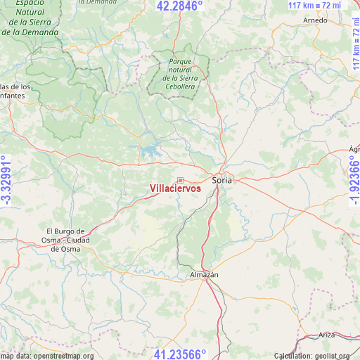
Villaciervos GPS coordinates[2]
41° 45' 44.172" North, 2° 37' 36.408" West
| Map corner | latitude | longitude |
|---|---|---|
| Upper-left | 42.2846°, | -3.32991° |
| Center: | 41.76227°, | -2.62678° |
| Lower-right: | 41.23566°, | -1.92366° |
| Map W x H: | 116.6×116.6 km | = 72.5×72.5mi |
| max Lat: | 43.74134° ⇑32.4% North |
| Villaciervos: | 41.76227° |
| min Lat: | ⇓67.6% South 27.64134° |
| min Long | Villaciervos | max Long |
| -18.00367° | -2.62678° | 4.2899° |
| W 59.5%⇐ | ⇒40.5% E |
Elevation
Elevation of Villaciervos is 1182 m = 3878 ft, and this is 584 m = 1916 ft above average elevation for this country.
| Max E: |
1682 m = 5518 ft | 3.7% |
| Villaciervos | 1182 m 3878 ft | |
| Avg. | 598 m = 1962 ft | |
Min E: |
0 m = 0 ft | 96.3% |
See also: Spain elevation on elevation.city.
Geographical zone
Villaciervos is located in North temperate zone (between Tropic of Cancer and the Arctic Circle). Distance of this Northern Tropic circle is 2037.6 km =1266.1 mi to South.| Distance of | km | miles | from Villaciervos |
|---|---|---|---|
| North Pole | 5363.5 | 3332.7 | to North |
| Arctic Circle | 2757.6 | 1713.5 | to North |
| Tropic Cancer | 2037.6 | 1266.1 | to South |
| Equator | 4643.5 | 2885.3 | to South |


Nearby cities:
15 places around Villaciervos: (largest is in red/bold)
• Abejar
14 km =8.7 mi,  291°
291°
• Cabrejas del Pinar
18.8 km =11.7 mi,  281°
281°
• Calatañazor
17.4 km =10.8 mi,  246°
246°
• Cidones
5.9 km =3.7 mi,  349°
349°
• Fuentecantos
19.1 km =11.9 mi,  59°
59°
• Garray
16.1 km =10 mi,  68°
68°
• Golmayo
8.6 km =5.3 mi,  87°
87°
• Molinos de Duero
19.1 km =11.9 mi,  316°
316°
• Muriel de la Fuente
19.8 km =12.3 mi,  257°
257°
• Quintana Redonda
13.7 km =8.5 mi,  175°
175°
• Rollamienta
19.8 km =12.3 mi,  23°
23°
• Soria
13.1 km =8.1 mi, 89°
• Sotillo del Rincón
19 km =11.8 mi,  5°
5°
• Tardelcuende
18.8 km =11.7 mi, 184°
• Villar del Ala
17.8 km =11.1 mi, 16°
Sources, notices
• [Note1] Compared only with cities in Spain existing in our database
• [Src1] Map data: © OpenStreetMap contributors (CC-BY-SA)
• [Src2] Other city data from geonames.org with taken over terms of usage.
• [Src3] Geographical zone / Annual Mean Temperature by Robert A. Rohde @ Wikipedia
