Blancafort geodata
Blancafort (Catalonia) is a seat of a third-order administrative division; located in Spain in Europe/Madrid (GMT+2) time zone. In our database, there are 6762 cities with bigger population. Compared to other cities in Spain, 59.2% of cities are located further ↓South; 90.9% of cities are located further ←West and 67% of cities have higher elevation than Blancafort. Note1


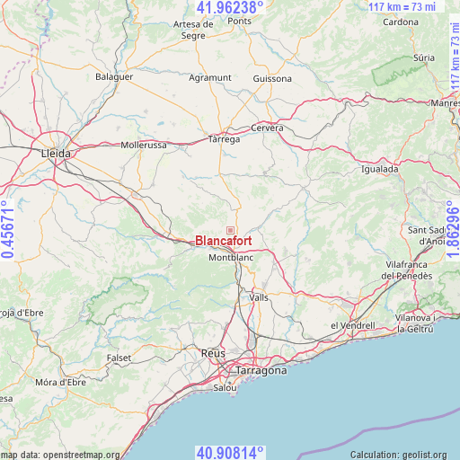
Blancafort GPS coordinates[2]
41° 26' 14.64" North, 1° 9' 35.388" East
| Map corner | latitude | longitude |
|---|---|---|
| Upper-left | 41.96238°, | 0.45671° |
| Center: | 41.4374°, | 1.15983° |
| Lower-right: | 40.90814°, | 1.86296° |
| Map W x H: | 117.2×117.2 km | = 72.8×72.8mi |
| max Lat: | 43.74134° ⇑40.8% North |
| Blancafort: | 41.4374° |
| min Lat: | ⇓59.2% South 27.64134° |
| min Long | Blancafort | max Long |
| -18.00367° | 1.15983° | 4.2899° |
| W 90.9%⇐ | ⇒9.1% E |
Elevation
Elevation of Blancafort is 433 m = 1421 ft, and this is 165 m = 541 ft below average elevation for this country.
| Max E: |
1682 m = 5518 ft | 67% |
| Avg. | 598 m = 1962 ft | |
| Blancafort | 433 m = 1421 ft | |
Min E: |
0 m = 0 ft | 33% |
See also: Spain elevation on elevation.city.
Geographical zone
Blancafort is located in North temperate zone (between Tropic of Cancer and the Arctic Circle). Distance of this Northern Tropic circle is 2001.5 km =1243.7 mi to South.| Distance of | km | miles | from Blancafort |
|---|---|---|---|
| North Pole | 5399.7 | 3355.2 | to North |
| Arctic Circle | 2793.8 | 1736 | to North |
| Tropic Cancer | 2001.5 | 1243.7 | to South |
| Equator | 4607.4 | 2862.9 | to South |


Nearby cities:
15 places around Blancafort: (largest is in red/bold)
• Cabra del Camp
11.1 km =6.9 mi,  111°
111°
• Ciutadilla
13.9 km =8.6 mi,  352°
352°
• Conesa
14.6 km =9.1 mi,  52°
52°
• El Pla de Santa Maria
13.7 km =8.5 mi,  126°
126°
• Forès
8 km =5 mi, 50°
• Fulleda
11.7 km =7.3 mi,  284°
284°
• Guimerà
14.3 km =8.9 mi,  8°
8°
• La Riba
13.1 km =8.1 mi,  174°
174°
• Montblanc
6.8 km =4.2 mi,  178°
178°
• Nalec
13 km =8.1 mi,  343°
343°
• Senan
7.2 km =4.5 mi,  300°
300°
• Vallbona de les Monges
11.5 km =7.1 mi,  329°
329°
• Vallfogona de Riucorb
15.3 km =9.5 mi,  24°
24°
• Vimbodí
10 km =6.2 mi,  245°
245°
• Vinaixa
14.7 km =9.1 mi,  268°
268°
Sources, notices
• [Note1] Compared only with cities in Spain existing in our database
• [Src1] Map data: © OpenStreetMap contributors (CC-BY-SA)
• [Src2] Other city data from geonames.org with taken over terms of usage.
• [Src3] Geographical zone / Annual Mean Temperature by Robert A. Rohde @ Wikipedia
