Conesa geodata
Conesa (Catalonia) is a seat of a third-order administrative division; located in Spain in Europe/Madrid (GMT+2) time zone. In our database, there are 6762 cities with bigger population. Compared to other cities in Spain, 61.1% of cities are located further ↓South; 91.3% of cities are located further ←West and 57.8% of cities have lower elevation than Conesa. Note1


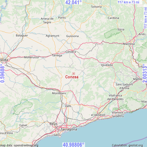
Conesa GPS coordinates[2]
41° 31' 0.012" North, 1° 18' 0" East
| Map corner | latitude | longitude |
|---|---|---|
| Upper-left | 42.041°, | 0.59688° |
| Center: | 41.51667°, | 1.3° |
| Lower-right: | 40.98806°, | 2.00313° |
| Map W x H: | 117.1×117.1 km | = 72.8×72.8mi |
| max Lat: | 43.74134° ⇑38.9% North |
| Conesa: | 41.51667° |
| min Lat: | ⇓61.1% South 27.64134° |
| min Long | Conesa | max Long |
| -18.00367° | 1.3° | 4.2899° |
| W 91.3%⇐ | ⇒8.7% E |
Elevation
Elevation of Conesa is 728 m = 2388 ft, and this is 130 m = 427 ft above average elevation for this country.
| Max E: |
1682 m = 5518 ft | 42.2% |
| Conesa | 728 m 2388 ft | |
| Avg. | 598 m = 1962 ft | |
Min E: |
0 m = 0 ft | 57.8% |
See also: Spain elevation on elevation.city.
Geographical zone
Conesa is located in North temperate zone (between Tropic of Cancer and the Arctic Circle). Distance of this Northern Tropic circle is 2010.3 km =1249.1 mi to South.| Distance of | km | miles | from Conesa |
|---|---|---|---|
| North Pole | 5390.8 | 3349.7 | to North |
| Arctic Circle | 2785 | 1730.5 | to North |
| Tropic Cancer | 2010.3 | 1249.1 | to South |
| Equator | 4616.2 | 2868.4 | to South |


Nearby cities:
15 places around Conesa: (largest is in red/bold)
• Argensola
15.1 km =9.4 mi,  53°
53°
• Bellprat
11.1 km =6.9 mi,  89°
89°
• Blancafort
14.6 km =9.1 mi,  232°
232°
• Cabra del Camp
13 km =8.1 mi,  186°
186°
• Cervera
17.2 km =10.7 mi,  352°
352°
• Ciutadilla
14.3 km =8.9 mi,  290°
290°
• El Pla de Santa Maria
17.1 km =10.6 mi,  182°
182°
• Forès
6.7 km =4.2 mi,  236°
236°
• Guimerà
10.9 km =6.8 mi,  299°
299°
• Nalec
15.7 km =9.8 mi,  283°
283°
• Pontils
8.5 km =5.3 mi,  120°
120°
• Querol
13.2 km =8.2 mi,  142°
142°
• Santa Coloma de Queralt
7.2 km =4.5 mi,  75°
75°
• Vallfogona de Riucorb
7.3 km =4.5 mi,  314°
314°
• Verdú
16.7 km =10.4 mi, 308°
Sources, notices
• [Note1] Compared only with cities in Spain existing in our database
• [Src1] Map data: © OpenStreetMap contributors (CC-BY-SA)
• [Src2] Other city data from geonames.org with taken over terms of usage.
• [Src3] Geographical zone / Annual Mean Temperature by Robert A. Rohde @ Wikipedia
