Forès geodata
Forès (Catalonia) is a seat of a third-order administrative division; located in Spain in Europe/Madrid (GMT+2) time zone. In our database, there are 6762 cities with bigger population. Compared to other cities in Spain, 60.4% of cities are located further ↓South; 91.1% of cities are located further ←West and 53.1% of cities have higher elevation than Forès. Note1


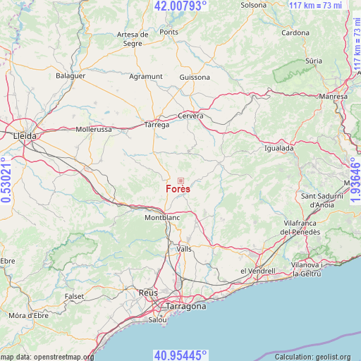
Forès GPS coordinates[2]
41° 28' 59.988" North, 1° 13' 59.988" East
| Map corner | latitude | longitude |
|---|---|---|
| Upper-left | 42.00793°, | 0.53021° |
| Center: | 41.48333°, | 1.23333° |
| Lower-right: | 40.95445°, | 1.93646° |
| Map W x H: | 117.1×117.1 km | = 72.8×72.8mi |
| max Lat: | 43.74134° ⇑39.6% North |
| Forès: | 41.48333° |
| min Lat: | ⇓60.4% South 27.64134° |
| min Long | Forès | max Long |
| -18.00367° | 1.23333° | 4.2899° |
| W 91.1%⇐ | ⇒8.9% E |
Elevation
Elevation of Forès is 622 m = 2041 ft, and this is 24 m = 79 ft above average elevation for this country.
| Max E: |
1682 m = 5518 ft | 53.1% |
| Forès | 622 m 2041 ft | |
| Avg. | 598 m = 1962 ft | |
Min E: |
0 m = 0 ft | 46.9% |
See also: Spain elevation on elevation.city.
Geographical zone
Forès is located in North temperate zone (between Tropic of Cancer and the Arctic Circle). Distance of this Northern Tropic circle is 2006.6 km =1246.8 mi to South.| Distance of | km | miles | from Forès |
|---|---|---|---|
| North Pole | 5394.5 | 3352 | to North |
| Arctic Circle | 2788.7 | 1732.8 | to North |
| Tropic Cancer | 2006.6 | 1246.8 | to South |
| Equator | 4612.5 | 2866.1 | to South |


Nearby cities:
15 places around Forès: (largest is in red/bold)
• Blancafort
8 km =5 mi,  230°
230°
• Cabra del Camp
10.2 km =6.3 mi,  155°
155°
• Ciutadilla
11.7 km =7.3 mi,  317°
317°
• Conesa
6.7 km =4.2 mi,  56°
56°
• El Pla de Santa Maria
14.2 km =8.8 mi, 160°
• Guimerà
9.9 km =6.2 mi,  336°
336°
• Montblanc
13.3 km =8.3 mi,  206°
206°
• Nalec
12.2 km =7.6 mi,  307°
307°
• Pontils
12.9 km =8 mi,  92°
92°
• Querol
15.2 km =9.4 mi,  116°
116°
• Santa Coloma de Queralt
13.7 km =8.5 mi,  66°
66°
• Senan
12.4 km =7.7 mi,  263°
263°
• Vallbona de les Monges
13 km =8.1 mi,  291°
291°
• Vallfogona de Riucorb
8.8 km =5.5 mi,  1°
1°
• Verdú
16 km =9.9 mi,  331°
331°
Sources, notices
• [Note1] Compared only with cities in Spain existing in our database
• [Src1] Map data: © OpenStreetMap contributors (CC-BY-SA)
• [Src2] Other city data from geonames.org with taken over terms of usage.
• [Src3] Geographical zone / Annual Mean Temperature by Robert A. Rohde @ Wikipedia
