Vallfogona de Riucorb geodata
Vallfogona de Riucorb (Catalonia) is a seat of a third-order administrative division; located in Spain in Europe/Madrid (GMT+2) time zone. In our database, there are 6762 cities with bigger population. Compared to other cities in Spain, 62.5% of cities are located further ↓South; 91.1% of cities are located further ←West and 55.8% of cities have higher elevation than Vallfogona de Riucorb. Note1
Administrative division(s):
- Level 1: Catalonia
- Level 2: Província de Tarragona
- Level 3: Vallfogona de Riucorb
Current local time in Vallfogona de Riucorb:
11:53 PM, ThursdayDifference from your time zone: hours


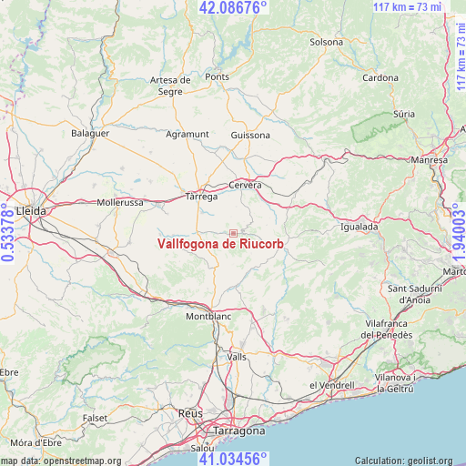
Vallfogona de Riucorb GPS coordinates[2]
41° 33' 46.08" North, 1° 14' 12.876" East
| Map corner | latitude | longitude |
|---|---|---|
| Upper-left | 42.08676°, | 0.53378° |
| Center: | 41.5628°, | 1.23691° |
| Lower-right: | 41.03456°, | 1.94003° |
| Map W x H: | 117×117 km | = 72.7×72.7mi |
| max Lat: | 43.74134° ⇑37.5% North |
| Vallfogona de Riucorb: | 41.5628° |
| min Lat: | ⇓62.5% South 27.64134° |
| min Long | Vallfogona de R | max Long |
| -18.00367° | 1.23691° | 4.2899° |
| W 91.1%⇐ | ⇒8.9% E |
Elevation
Elevation of Vallfogona de Riucorb is 585 m = 1919 ft, and this is 13 m = 43 ft below average elevation for this country.
| Max E: |
1682 m = 5518 ft | 55.8% |
| Avg. | 598 m = 1962 ft | |
| Vallfogona de Riucorb | 585 m = 1919 ft | |
Min E: |
0 m = 0 ft | 44.2% |
See also: Spain elevation on elevation.city.
Geographical zone
Vallfogona de Riucorb is located in North temperate zone (between Tropic of Cancer and the Arctic Circle). Distance of this Northern Tropic circle is 2015.4 km =1252.3 mi to South.| Distance of | km | miles | from Vallfogona de Riucorb |
|---|---|---|---|
| North Pole | 5385.7 | 3346.5 | to North |
| Arctic Circle | 2779.8 | 1727.3 | to North |
| Tropic Cancer | 2015.4 | 1252.3 | to South |
| Equator | 4621.4 | 2871.6 | to South |


Nearby cities:
15 places around Vallfogona de Riucorb: (largest is in red/bold)
• Anglesola
16.5 km =10.3 mi,  309°
309°
• Bellprat
17.1 km =10.6 mi,  107°
107°
• Blancafort
15.3 km =9.5 mi,  204°
204°
• Cervera
12.3 km =7.6 mi,  13°
13°
• Ciutadilla
8.1 km =5 mi,  268°
268°
• Conesa
7.3 km =4.5 mi,  134°
134°
• Forès
8.8 km =5.5 mi,  181°
181°
• Guimerà
4.3 km =2.7 mi, 272°
• Nalec
10.1 km =6.3 mi,  261°
261°
• Pontils
15.7 km =9.8 mi, 127°
• Santa Coloma de Queralt
12.6 km =7.8 mi, 105°
• Senan
16.3 km =10.1 mi,  230°
230°
• Tàrrega
12.4 km =7.7 mi,  319°
319°
• Vallbona de les Monges
13 km =8.1 mi,  251°
251°
• Verdú
9.5 km =5.9 mi,  304°
304°
In other languages:
- In Spanish: Vallfogona de Riucorp
- In Russian: Вальфогона-де-Риукорб
- In Chinese: 巴利福戈纳德留科尔布
Sources, notices
• [Note1] Compared only with cities in Spain existing in our database
• [Src1] Map data: © OpenStreetMap contributors (CC-BY-SA)
• [Src2] Other city data from geonames.org with taken over terms of usage.
• [Src3] Geographical zone / Annual Mean Temperature by Robert A. Rohde @ Wikipedia
