Guimerà geodata
Guimerà (Catalonia) is a seat of a third-order administrative division; located in Spain in Europe/Madrid (GMT+2) time zone. With population of 370 people, there are 4238 cities with bigger population in this country. Compared to other cities in Spain, 62.5% of cities are located further ↓South; 91% of cities are located further ←West and 60.9% of cities have higher elevation than Guimerà. Note1


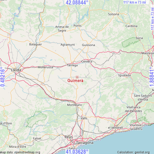
Guimerà GPS coordinates[2]
41° 33' 52.2" North, 1° 11' 7.008" East
| Map corner | latitude | longitude |
|---|---|---|
| Upper-left | 42.08844°, | 0.48216° |
| Center: | 41.5645°, | 1.18528° |
| Lower-right: | 41.03628°, | 1.88841° |
| Map W x H: | 117×117 km | = 72.7×72.7mi |
| max Lat: | 43.74134° ⇑37.5% North |
| Guimerà: | 41.5645° |
| min Lat: | ⇓62.5% South 27.64134° |
| min Long | Guimerà | max Long |
| -18.00367° | 1.18528° | 4.2899° |
| W 91%⇐ | ⇒9% E |
Elevation
Elevation of Guimerà is 514 m = 1686 ft, and this is 84 m = 276 ft below average elevation for this country.
| Max E: |
1682 m = 5518 ft | 60.9% |
| Avg. | 598 m = 1962 ft | |
| Guimerà | 514 m = 1686 ft | |
Min E: |
0 m = 0 ft | 39.1% |
See also: Spain elevation on elevation.city.
Geographical zone
Guimerà is located in North temperate zone (between Tropic of Cancer and the Arctic Circle). Distance of this Northern Tropic circle is 2015.6 km =1252.4 mi to South.| Distance of | km | miles | from Guimerà |
|---|---|---|---|
| North Pole | 5385.5 | 3346.4 | to North |
| Arctic Circle | 2779.6 | 1727.2 | to North |
| Tropic Cancer | 2015.6 | 1252.4 | to South |
| Equator | 4621.5 | 2871.7 | to South |


Nearby cities:
15 places around Guimerà: (largest is in red/bold)
• Anglesola
13.3 km =8.3 mi,  320°
320°
• Belianes
14.1 km =8.8 mi,  268°
268°
• Bellpuig
16 km =9.9 mi,  295°
295°
• Blancafort
14.3 km =8.9 mi,  188°
188°
• Cervera
13.8 km =8.6 mi,  31°
31°
• Ciutadilla
3.8 km =2.4 mi,  264°
264°
• Conesa
10.9 km =6.8 mi,  119°
119°
• Forès
9.9 km =6.2 mi,  156°
156°
• Nalec
5.9 km =3.7 mi,  254°
254°
• Santa Coloma de Queralt
16.8 km =10.4 mi,  101°
101°
• Senan
13.4 km =8.3 mi,  218°
218°
• Tàrrega
9.9 km =6.2 mi,  337°
337°
• Vallbona de les Monges
9.1 km =5.7 mi,  242°
242°
• Vallfogona de Riucorb
4.3 km =2.7 mi,  92°
92°
• Verdú
6.2 km =3.9 mi,  325°
325°
Sources, notices
• [Note1] Compared only with cities in Spain existing in our database
• [Src1] Map data: © OpenStreetMap contributors (CC-BY-SA)
• [Src2] Other city data from geonames.org with taken over terms of usage.
• [Src3] Geographical zone / Annual Mean Temperature by Robert A. Rohde @ Wikipedia
