Arganzuela geodata
Arganzuela (Madrid) is a section of populated place; located in Spain in Europe/Madrid (GMT+2) time zone. With population of 148,797 people, there are 58 cities with bigger population in this country. Compared to other cities in Spain, 64% of cities are located further ↑North; 55.3% of cities are located further →East and 54.4% of cities have higher elevation than Arganzuela. Note1
Administrative division(s):
- Level 1: Madrid
- Level 2: Provincia de Madrid
- Level 3: Madrid
- Level 4: Arganzuela


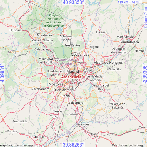
Arganzuela GPS coordinates[2]
40° 24' 0.756" North, 3° 41' 46.248" West
| Map corner | latitude | longitude |
|---|---|---|
| Upper-left | 40.93353°, | -4.39931° |
| Center: | 40.40021°, | -3.69618° |
| Lower-right: | 39.86263°, | -2.99306° |
| Map W x H: | 119.1×119.1 km | = 74×74mi |
| max Lat: | 43.74134° ⇑64% North |
| Arganzuela: | 40.40021° |
| min Lat: | ⇓36% South 27.64134° |
| min Long | Arganzuela | max Long |
| -18.00367° | -3.69618° | 4.2899° |
| W 44.7%⇐ | ⇒55.3% E |
Elevation
Elevation of Arganzuela is 605 m = 1985 ft, and this is 7 m = 23 ft above average elevation for this country.
| Max E: |
1682 m = 5518 ft | 54.4% |
| Arganzuela | 605 m 1985 ft | |
| Avg. | 598 m = 1962 ft | |
Min E: |
0 m = 0 ft | 45.6% |
See also: Arganzuela elevation on elevation.city.
Geographical zone
Arganzuela is located in North temperate zone (between Tropic of Cancer and the Arctic Circle). Distance of this Northern Tropic circle is 1886.2 km =1172 mi to South.| Distance of | km | miles | from Arganzuela |
|---|---|---|---|
| North Pole | 5515 | 3426.9 | to North |
| Arctic Circle | 2909.1 | 1807.6 | to North |
| Tropic Cancer | 1886.2 | 1172 | to South |
| Equator | 4492.1 | 2791.3 | to South |


Nearby cities:
15 places around Arganzuela: (largest is in red/bold)
• Carabanchel
2.6 km =1.6 mi,  246°
246°
• Chamartín
7.1 km =4.4 mi,  13°
13°
• Chamberí
3.8 km =2.4 mi,  350°
350°
• City Center
2.1 km =1.3 mi,  344°
344°
• Ciudad Lineal
6.3 km =3.9 mi,  37°
37°
• Latina
4.4 km =2.7 mi, 253°
• Madrid
1.9 km =1.2 mi, 343°
• Moncloa-Aravaca
4.9 km =3 mi,  322°
322°
• Moratalaz
4 km =2.5 mi,  78°
78°
• Puente de Vallecas
3 km =1.9 mi,  104°
104°
• Retiro
1.8 km =1.1 mi, 37°
• Salamanca
3.6 km =2.2 mi,  22°
22°
• Tetuán de las Victorias
6.6 km =4.1 mi,  359°
359°
• Usera
1.3 km =0.8 mi,  195°
195°
• Villaverde
5.6 km =3.5 mi,  183°
183°
Sources, notices
• [Note1] Compared only with cities in Spain existing in our database
• [Src1] Map data: © OpenStreetMap contributors (CC-BY-SA)
• [Src2] Other city data from geonames.org with taken over terms of usage.
• [Src3] Geographical zone / Annual Mean Temperature by Robert A. Rohde @ Wikipedia
