Moratalaz geodata
Moratalaz (Madrid) is a section of populated place; located in Spain in Europe/Madrid (GMT+2) time zone. With population of 104,923 people, there are 86 cities with bigger population in this country. Compared to other cities in Spain, 63.9% of cities are located further ↑North; 54.6% of cities are located further →East and 51.2% of cities have lower elevation than Moratalaz. Note1
Administrative division(s):
- Level 1: Madrid
- Level 2: Provincia de Madrid
- Level 3: Madrid
- Level 4: Moratalaz


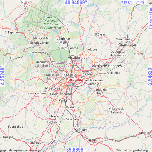
Moratalaz GPS coordinates[2]
40° 24' 26.712" North, 3° 38' 57.66" West
| Map corner | latitude | longitude |
|---|---|---|
| Upper-left | 40.94069°, | -4.35248° |
| Center: | 40.40742°, | -3.64935° |
| Lower-right: | 39.8699°, | -2.94623° |
| Map W x H: | 119.1×119.1 km | = 74×74mi |
| max Lat: | 43.74134° ⇑63.9% North |
| Moratalaz: | 40.40742° |
| min Lat: | ⇓36.1% South 27.64134° |
| min Long | Moratalaz | max Long |
| -18.00367° | -3.64935° | 4.2899° |
| W 45.4%⇐ | ⇒54.6% E |
Elevation
Elevation of Moratalaz is 671 m = 2201 ft, and this is 73 m = 240 ft above average elevation for this country.
| Max E: |
1682 m = 5518 ft | 48.8% |
| Moratalaz | 671 m 2201 ft | |
| Avg. | 598 m = 1962 ft | |
Min E: |
0 m = 0 ft | 51.2% |
See also: Moratalaz elevation on elevation.city.
Geographical zone
Moratalaz is located in North temperate zone (between Tropic of Cancer and the Arctic Circle). Distance of this Northern Tropic circle is 1887 km =1172.5 mi to South.| Distance of | km | miles | from Moratalaz |
|---|---|---|---|
| North Pole | 5514.2 | 3426.4 | to North |
| Arctic Circle | 2908.3 | 1807.1 | to North |
| Tropic Cancer | 1887 | 1172.5 | to South |
| Equator | 4492.9 | 2791.8 | to South |


Nearby cities:
15 places around Moratalaz: (largest is in red/bold)
• Arganzuela
4 km =2.5 mi,  258°
258°
• Carabanchel
6.6 km =4.1 mi,  253°
253°
• Chamartín
6.5 km =4 mi,  339°
339°
• Chamberí
5.5 km =3.4 mi,  302°
302°
• City Center
4.7 km =2.9 mi,  284°
284°
• Ciudad Lineal
4.2 km =2.6 mi,  357°
357°
• Madrid
4.6 km =2.9 mi, 282°
• Puente de Vallecas
1.9 km =1.2 mi,  214°
214°
• Retiro
2.9 km =1.8 mi, 282°
• Salamanca
3.6 km =2.2 mi,  313°
313°
• San Blas-Canillejas
4.5 km =2.8 mi,  39°
39°
• Tetuán de las Victorias
7.1 km =4.4 mi,  324°
324°
• Usera
4.8 km =3 mi,  244°
244°
• Vicálvaro
4.3 km =2.7 mi,  101°
101°
• Villa de Vallecas
6.1 km =3.8 mi,  137°
137°
Sources, notices
• [Note1] Compared only with cities in Spain existing in our database
• [Src1] Map data: © OpenStreetMap contributors (CC-BY-SA)
• [Src2] Other city data from geonames.org with taken over terms of usage.
• [Src3] Geographical zone / Annual Mean Temperature by Robert A. Rohde @ Wikipedia
