San Pedro Galdames geodata
San Pedro Galdames (Basque Country) is a populated place; located in Spain in Europe/Madrid (GMT+2) time zone. With population of 812 people, there are 3186 cities with bigger population in this country. Compared to other cities in Spain, 96.9% of cities are located further ↓South; 52.7% of cities are located further ←West and 82.2% of cities have higher elevation than San Pedro Galdames. Note1


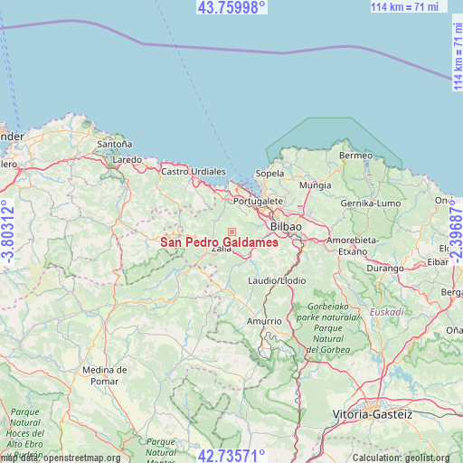
San Pedro Galdames GPS coordinates[2]
43° 15' 0" North, 3° 6' 0" West
| Map corner | latitude | longitude |
|---|---|---|
| Upper-left | 43.75998°, | -3.80312° |
| Center: | 43.25°, | -3.1° |
| Lower-right: | 42.73571°, | -2.39687° |
| Map W x H: | 113.9×113.9 km | = 70.8×70.8mi |
| max Lat: | 43.74134° ⇑3.1% North |
| San Pedro Galdames: | 43.25° |
| min Lat: | ⇓96.9% South 27.64134° |
| min Long | San Pedro Galda | max Long |
| -18.00367° | -3.1° | 4.2899° |
| W 52.7%⇐ | ⇒47.3% E |
Elevation
Elevation of San Pedro Galdames is 182 m = 597 ft, and this is 416 m = 1365 ft below average elevation for this country.
| Max E: |
1682 m = 5518 ft | 82.2% |
| Avg. | 598 m = 1962 ft | |
| San Pedro Galdames | 182 m = 597 ft | |
Min E: |
0 m = 0 ft | 17.8% |
See also: Spain elevation on elevation.city.
Geographical zone
San Pedro Galdames is located in North temperate zone (between Tropic of Cancer and the Arctic Circle). Distance of this Northern Tropic circle is 2203 km =1368.9 mi to South.| Distance of | km | miles | from San Pedro Galdames |
|---|---|---|---|
| North Pole | 5198.1 | 3229.9 | to North |
| Arctic Circle | 2592.2 | 1610.7 | to North |
| Tropic Cancer | 2203 | 1368.9 | to South |
| Equator | 4808.9 | 2988.1 | to South |


Nearby cities:
15 places around San Pedro Galdames: (largest is in red/bold)
• Alonsotegi
9.1 km =5.7 mi,  93°
93°
• Avellaneda
5.5 km =3.4 mi,  245°
245°
• Balmaseda
9.8 km =6.1 mi,  235°
235°
• Barakaldo
10.4 km =6.5 mi,  60°
60°
• Erandio
11.9 km =7.4 mi, 59°
• Gordexola
8.2 km =5.1 mi,  166°
166°
• Güeñes
4.2 km =2.6 mi, 174°
• Ortuella
7.7 km =4.8 mi,  27°
27°
• Portugalete
10.2 km =6.3 mi,  39°
39°
• San Julián de Muskiz
9.3 km =5.8 mi,  0°
0°
• Santurtzi
10.3 km =6.4 mi, 32°
• Sestao
10 km =6.2 mi,  48°
48°
• Sopuerta
4.7 km =2.9 mi,  287°
287°
• Zalla
3.3 km =2.1 mi, 235°
• Zierbena
11.2 km =7 mi,  6°
6°
Sources, notices
• [Note1] Compared only with cities in Spain existing in our database
• [Src1] Map data: © OpenStreetMap contributors (CC-BY-SA)
• [Src2] Other city data from geonames.org with taken over terms of usage.
• [Src3] Geographical zone / Annual Mean Temperature by Robert A. Rohde @ Wikipedia
