Kalvola geodata
Kalvola (Kanta-Hame) is a populated place; located in Finland in Europe/Helsinki (GMT+3) time zone. With population of 3,406 people, there are 275 cities with bigger population in this country. Compared to other cities in Finland, 66.5% of cities are located further ↑North; 59.2% of cities are located further →East and 88.2% of cities have lower elevation than Kalvola. Note1


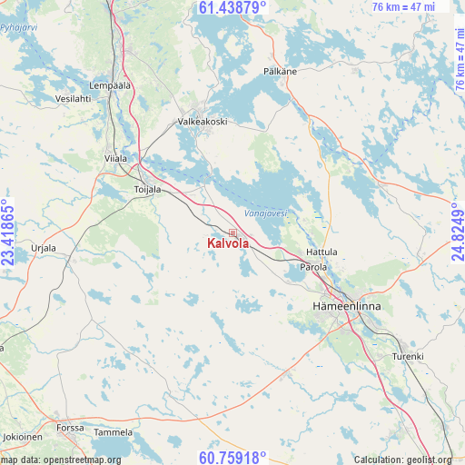
Kalvola GPS coordinates[2]
61° 6' 2.916" North, 24° 7' 18.372" East
| Map corner | latitude | longitude |
|---|---|---|
| Upper-left | 61.43879°, | 23.41865° |
| Center: | 61.10081°, | 24.12177° |
| Lower-right: | 60.75918°, | 24.8249° |
| Map W x H: | 75.6×75.6 km | = 47×47mi |
| max Lat: | 69.90864° ⇑66.5% North |
| Kalvola: | 61.10081° |
| min Lat: | ⇓33.5% South 59.83333° |
| min Long | Kalvola | max Long |
| 21.2° | 24.12177° | 30.93276° |
| W 40.8%⇐ | ⇒59.2% E |
Elevation
Elevation of Kalvola is 137 m = 449 ft, and this is 59.9 m = 197 ft above average elevation for this country.
| Max E: |
299 m = 981 ft | 11.8% |
| Kalvola | 137 m 449 ft | |
| Avg. | 77.1 m = 253 ft | |
Min E: |
1 m = 3 ft | 88.2% |
See also: Finland elevation on elevation.city.
Geographical zone
Kalvola is located in North temperate zone (between Tropic of Cancer and the Arctic Circle). Distance of this North polar circle is 607.4 km =377.4 mi to North.| Distance of | km | miles | from Kalvola |
|---|---|---|---|
| North Pole | 3213.3 | 1996.7 | to North |
| Arctic Circle | 607.4 | 377.4 | to North |
| Tropic Cancer | 4187.9 | 2602.2 | to South |
| Equator | 6793.8 | 4221.5 | to South |


Nearby cities:
15 places around Kalvola: (largest is in red/bold)
• Akaa
15.5 km =9.6 mi,  298°
298°
• Hauho
25 km =15.5 mi,  71°
71°
• Hämeenlinna
21.8 km =13.5 mi,  122°
122°
• Janakkala
34.1 km =21.2 mi,  130°
130°
• Kylmäkoski
24 km =14.9 mi,  284°
284°
• Lempäälä
31.2 km =19.4 mi,  320°
320°
• Parola
13.9 km =8.6 mi, 115°
• Pälkäne
27.2 km =16.9 mi,  17°
17°
• Renko
24.5 km =15.2 mi,  158°
158°
• Toijala
16.9 km =10.5 mi, 296°
• Turenki
34.3 km =21.3 mi, 126°
• Urjala
31.7 km =19.7 mi,  266°
266°
• Valkeakoski
18.8 km =11.7 mi,  345°
345°
• Vesilahti
36.2 km =22.5 mi,  311°
311°
• Viiala
22.6 km =14 mi, 302°
Sources, notices
• [Note1] Compared only with cities in Finland existing in our database
• [Src1] Map data: © OpenStreetMap contributors (CC-BY-SA)
• [Src2] Other city data from geonames.org with taken over terms of usage.
• [Src3] Geographical zone / Annual Mean Temperature by Robert A. Rohde @ Wikipedia
