Vampula geodata
Vampula (Satakunta) is a seat of a third-order administrative division; located in Finland in Europe/Helsinki (GMT+3) time zone. With population of 1,743 people, there are 375 cities with bigger population in this country. Compared to other cities in Finland, 69% of cities are located further ↑North; 80.3% of cities are located further →East and 53.2% of cities have higher elevation than Vampula. Note1


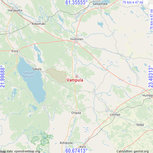
Vampula GPS coordinates[2]
61° 1' 0.012" North, 22° 42' 0" East
| Map corner | latitude | longitude |
|---|---|---|
| Upper-left | 61.35555°, | 21.99688° |
| Center: | 61.01667°, | 22.7° |
| Lower-right: | 60.67413°, | 23.40313° |
| Map W x H: | 75.8×75.8 km | = 47.1×47.1mi |
| max Lat: | 69.90864° ⇑69% North |
| Vampula: | 61.01667° |
| min Lat: | ⇓31% South 59.83333° |
| min Long | Vampula | max Long |
| 21.2° | 22.7° | 30.93276° |
| W 19.7%⇐ | ⇒80.3% E |
Elevation
Elevation of Vampula is 75 m = 246 ft, and this is 2.1 m = 7 ft below average elevation for this country.
| Max E: |
299 m = 981 ft | 53.2% |
| Avg. | 77.1 m = 253 ft | |
| Vampula | 75 m = 246 ft | |
Min E: |
1 m = 3 ft | 46.8% |
See also: Finland elevation on elevation.city.
Geographical zone
Vampula is located in North temperate zone (between Tropic of Cancer and the Arctic Circle). Distance of this North polar circle is 616.8 km =383.3 mi to North.| Distance of | km | miles | from Vampula |
|---|---|---|---|
| North Pole | 3222.6 | 2002.4 | to North |
| Arctic Circle | 616.8 | 383.3 | to North |
| Tropic Cancer | 4178.5 | 2596.4 | to South |
| Equator | 6784.4 | 4215.6 | to South |


Nearby cities:
15 places around Vampula: (largest is in red/bold)
• Alastaro
11 km =6.8 mi,  132°
132°
• Eura
33.1 km =20.6 mi,  293°
293°
• Huittinen
18.5 km =11.5 mi,  0°
0°
• Kokemäki
32.4 km =20.1 mi,  325°
325°
• Kyrö
35.3 km =21.9 mi,  175°
175°
• Köyliö
23.9 km =14.9 mi,  298°
298°
• Loimaa
26.7 km =16.6 mi, 133°
• Mellilä
30.9 km =19.2 mi,  154°
154°
• Oripää
18.6 km =11.6 mi, 182°
• Punkalaidun
24.2 km =15 mi,  62°
62°
• Pöytyä
27.9 km =17.3 mi, 183°
• Säkylä
19.8 km =12.3 mi,  275°
275°
• Vammala
36.8 km =22.9 mi,  16°
16°
• Yläne
21.3 km =13.2 mi,  225°
225°
• Äetsä
29.7 km =18.5 mi,  358°
358°
Sources, notices
• [Note1] Compared only with cities in Finland existing in our database
• [Src1] Map data: © OpenStreetMap contributors (CC-BY-SA)
• [Src2] Other city data from geonames.org with taken over terms of usage.
• [Src3] Geographical zone / Annual Mean Temperature by Robert A. Rohde @ Wikipedia
