Oripää geodata
Oripää (Southwest Finland) is a seat of a third-order administrative division; located in Finland in Europe/Helsinki (GMT+3) time zone. With population of 1,351 people, there are 404 cities with bigger population in this country. Compared to other cities in Finland, 73.3% of cities are located further ↑North; 81.6% of cities are located further →East and 58.1% of cities have higher elevation than Oripää. Note1


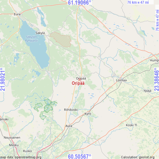
Oripää GPS coordinates[2]
60° 51' 0" North, 22° 40' 59.988" East
| Map corner | latitude | longitude |
|---|---|---|
| Upper-left | 61.19066°, | 21.98021° |
| Center: | 60.85°, | 22.68333° |
| Lower-right: | 60.50567°, | 23.38646° |
| Map W x H: | 76.2×76.2 km | = 47.3×47.3mi |
| max Lat: | 69.90864° ⇑73.3% North |
| Oripää: | 60.85° |
| min Lat: | ⇓26.7% South 59.83333° |
| min Long | Oripää | max Long |
| 21.2° | 22.68333° | 30.93276° |
| W 18.4%⇐ | ⇒81.6% E |
Elevation
Elevation of Oripää is 66 m = 217 ft, and this is 11.1 m = 36 ft below average elevation for this country.
| Max E: |
299 m = 981 ft | 58.1% |
| Avg. | 77.1 m = 253 ft | |
| Oripää | 66 m = 217 ft | |
Min E: |
1 m = 3 ft | 41.9% |
See also: Finland elevation on elevation.city.
Geographical zone
Oripää is located in North temperate zone (between Tropic of Cancer and the Arctic Circle). Distance of this North polar circle is 635.3 km =394.8 mi to North.| Distance of | km | miles | from Oripää |
|---|---|---|---|
| North Pole | 3241.2 | 2014 | to North |
| Arctic Circle | 635.3 | 394.8 | to North |
| Tropic Cancer | 4160 | 2584.9 | to South |
| Equator | 6765.9 | 4204.1 | to South |


Nearby cities:
15 places around Oripää: (largest is in red/bold)
• Alastaro
14.3 km =8.9 mi,  39°
39°
• Aura
23.2 km =14.4 mi,  192°
192°
• Karinainen
20.9 km =13 mi,  167°
167°
• Koski Tl
33.7 km =20.9 mi,  131°
131°
• Kyrö
17.1 km =10.6 mi, 167°
• Loimaa
20.2 km =12.6 mi,  90°
90°
• Marttila
31.9 km =19.8 mi,  158°
158°
• Mellilä
17.2 km =10.7 mi,  122°
122°
• Pöytyä
9.3 km =5.8 mi, 185°
• Säkylä
27.8 km =17.3 mi,  317°
317°
• Tarvasjoki
29.8 km =18.5 mi, 174°
• Vahto
34.7 km =21.6 mi,  216°
216°
• Vampula
18.6 km =11.6 mi,  2°
2°
• Yläne
14.9 km =9.3 mi,  284°
284°
• Ypäjä
33 km =20.5 mi,  99°
99°
Sources, notices
• [Note1] Compared only with cities in Finland existing in our database
• [Src1] Map data: © OpenStreetMap contributors (CC-BY-SA)
• [Src2] Other city data from geonames.org with taken over terms of usage.
• [Src3] Geographical zone / Annual Mean Temperature by Robert A. Rohde @ Wikipedia
