Köyliö geodata
Köyliö (Satakunta) is a populated place; located in Finland in Europe/Helsinki (GMT+3) time zone. With population of 2,901 people, there are 302 cities with bigger population in this country. Compared to other cities in Finland, 65.8% of cities are located further ↑North; 86.1% of cities are located further →East and 67.5% of cities have higher elevation than Köyliö. Note1


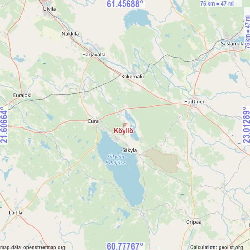
Köyliö GPS coordinates[2]
61° 7' 8.76" North, 22° 18' 35.136" East
| Map corner | latitude | longitude |
|---|---|---|
| Upper-left | 61.45688°, | 21.60664° |
| Center: | 61.1191°, | 22.30976° |
| Lower-right: | 60.77767°, | 23.01289° |
| Map W x H: | 75.5×75.5 km | = 46.9×46.9mi |
| max Lat: | 69.90864° ⇑65.8% North |
| Köyliö: | 61.1191° |
| min Lat: | ⇓34.2% South 59.83333° |
| min Long | Köyliö | max Long |
| 21.2° | 22.30976° | 30.93276° |
| W 13.9%⇐ | ⇒86.1% E |
Elevation
Elevation of Köyliö is 47 m = 154 ft, and this is 30.1 m = 99 ft below average elevation for this country.
| Max E: |
299 m = 981 ft | 67.5% |
| Avg. | 77.1 m = 253 ft | |
| Köyliö | 47 m = 154 ft | |
Min E: |
1 m = 3 ft | 32.5% |
See also: Finland elevation on elevation.city.
Geographical zone
Köyliö is located in North temperate zone (between Tropic of Cancer and the Arctic Circle). Distance of this North polar circle is 605.4 km =376.2 mi to North.| Distance of | km | miles | from Köyliö |
|---|---|---|---|
| North Pole | 3211.3 | 1995.4 | to North |
| Arctic Circle | 605.4 | 376.2 | to North |
| Tropic Cancer | 4189.9 | 2603.5 | to South |
| Equator | 6795.8 | 4222.7 | to South |


Nearby cities:
15 places around Köyliö: (largest is in red/bold)
• Alastaro
34.6 km =21.5 mi,  122°
122°
• Eura
9.6 km =6 mi,  279°
279°
• Eurajoki
32.2 km =20 mi,  286°
286°
• Harjavalta
23.9 km =14.9 mi,  336°
336°
• Huittinen
22.1 km =13.7 mi,  71°
71°
• Kiukainen
16.3 km =10.1 mi,  311°
311°
• Kodisjoki
34.3 km =21.3 mi,  253°
253°
• Kokemäki
15.5 km =9.6 mi,  9°
9°
• Lappi
25.7 km =16 mi,  265°
265°
• Nakkila
32.1 km =19.9 mi,  328°
328°
• Oripää
36.1 km =22.4 mi,  146°
146°
• Säkylä
9.6 km =6 mi,  172°
172°
• Vampula
23.9 km =14.9 mi, 118°
• Yläne
26.8 km =16.7 mi, 167°
• Äetsä
27.1 km =16.8 mi,  47°
47°
Sources, notices
• [Note1] Compared only with cities in Finland existing in our database
• [Src1] Map data: © OpenStreetMap contributors (CC-BY-SA)
• [Src2] Other city data from geonames.org with taken over terms of usage.
• [Src3] Geographical zone / Annual Mean Temperature by Robert A. Rohde @ Wikipedia
