Äetsä geodata
Äetsä (Pirkanmaa) is a populated place; located in Finland in Europe/Helsinki (GMT+3) time zone. With population of 4,929 people, there are 210 cities with bigger population in this country. Compared to other cities in Finland, 61.8% of cities are located further ↑North; 81.6% of cities are located further →East and 62.2% of cities have higher elevation than Äetsä. Note1


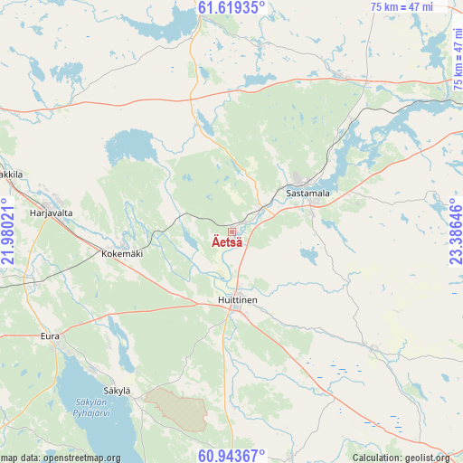
Äetsä GPS coordinates[2]
61° 16' 59.988" North, 22° 40' 59.988" East
| Map corner | latitude | longitude |
|---|---|---|
| Upper-left | 61.61935°, | 21.98021° |
| Center: | 61.28333°, | 22.68333° |
| Lower-right: | 60.94367°, | 23.38646° |
| Map W x H: | 75.1×75.1 km | = 46.7×46.7mi |
| max Lat: | 69.90864° ⇑61.8% North |
| Äetsä: | 61.28333° |
| min Lat: | ⇓38.2% South 59.83333° |
| min Long | Äetsä | max Long |
| 21.2° | 22.68333° | 30.93276° |
| W 18.4%⇐ | ⇒81.6% E |
Elevation
Elevation of Äetsä is 55 m = 180 ft, and this is 22.1 m = 73 ft below average elevation for this country.
| Max E: |
299 m = 981 ft | 62.2% |
| Avg. | 77.1 m = 253 ft | |
| Äetsä | 55 m = 180 ft | |
Min E: |
1 m = 3 ft | 37.8% |
See also: Finland elevation on elevation.city.
Geographical zone
Äetsä is located in North temperate zone (between Tropic of Cancer and the Arctic Circle). Distance of this North polar circle is 587.1 km =364.8 mi to North.| Distance of | km | miles | from Äetsä |
|---|---|---|---|
| North Pole | 3193 | 1984 | to North |
| Arctic Circle | 587.1 | 364.8 | to North |
| Tropic Cancer | 4208.1 | 2614.8 | to South |
| Equator | 6814.1 | 4234.1 | to South |


Nearby cities:
15 places around Äetsä: (largest is in red/bold)
• Eura
33.8 km =21 mi,  240°
240°
• Harjavalta
29.6 km =18.4 mi,  277°
277°
• Huittinen
11.2 km =7 mi,  175°
175°
• Kiikoinen
19.8 km =12.3 mi,  343°
343°
• Kiukainen
32.9 km =20.4 mi,  256°
256°
• Kokemäki
17.7 km =11 mi, 260°
• Kullaa
34.7 km =21.6 mi,  306°
306°
• Köyliö
27.1 km =16.8 mi,  227°
227°
• Lavia
35.5 km =22.1 mi,  352°
352°
• Mouhijärvi
29.9 km =18.6 mi,  36°
36°
• Punkalaidun
29 km =18 mi,  129°
129°
• Suodenniemi
31 km =19.3 mi,  10°
10°
• Säkylä
33.5 km =20.8 mi,  214°
214°
• Vammala
12.8 km =8 mi,  64°
64°
• Vampula
29.7 km =18.5 mi, 178°
Sources, notices
• [Note1] Compared only with cities in Finland existing in our database
• [Src1] Map data: © OpenStreetMap contributors (CC-BY-SA)
• [Src2] Other city data from geonames.org with taken over terms of usage.
• [Src3] Geographical zone / Annual Mean Temperature by Robert A. Rohde @ Wikipedia
