Salla geodata
Salla (Lapland) is a seat of a third-order administrative division; located in Finland in Europe/Helsinki (GMT+3) time zone. With population of 4,401 people, there are 234 cities with bigger population in this country. Compared to other cities in Finland, 97.4% of cities are located further ↓South; 92.9% of cities are located further ←West and 98.3% of cities have lower elevation than Salla. Note1


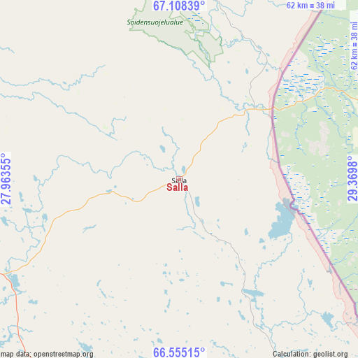
Salla GPS coordinates[2]
66° 49' 59.988" North, 28° 40' 0.012" East
| Map corner | latitude | longitude |
|---|---|---|
| Upper-left | 67.10839°, | 27.96355° |
| Center: | 66.83333°, | 28.66667° |
| Lower-right: | 66.55515°, | 29.3698° |
| Map W x H: | 61.5×61.5 km | = 38.2×38.2mi |
| max Lat: | 69.90864° ⇑2.6% North |
| Salla: | 66.83333° |
| min Lat: | ⇓97.4% South 59.83333° |
| min Long | Salla | max Long |
| 21.2° | 28.66667° | 30.93276° |
| W 92.9%⇐ | ⇒7.1% E |
Elevation
Elevation of Salla is 197 m = 646 ft, and this is 119.9 m = 393 ft above average elevation for this country.
| Max E: |
299 m = 981 ft | 1.7% |
| Salla | 197 m 646 ft | |
| Avg. | 77.1 m = 253 ft | |
Min E: |
1 m = 3 ft | 98.3% |
See also: Finland elevation on elevation.city.
Geographical zone
Salla is located in North Frigid zone (between North Pole and Arctic Circle). Distance of this North polar circle is 30 km =18.6 mi to South.| Distance of | km | miles | from Salla |
|---|---|---|---|
| North Pole | 2575.9 | 1600.6 | to North |
| Arctic Circle | 30 | 18.6 | to South |
| Tropic Cancer | 4825.3 | 2998.3 | to South |
| Equator | 7431.2 | 4617.5 | to South |


Nearby cities:
15 places around Salla: (largest is in red/bold)
• Kemijärvi
55.8 km =34.7 mi,  256°
256°
• Kittilä
186.7 km =116 mi,  299°
299°
• Kuusamo
99.1 km =61.6 mi,  166°
166°
• Levi
198 km =123 mi, 303°
• Pelkosenniemi
59 km =36.7 mi, 301°
• Posio
83.5 km =51.9 mi,  195°
195°
• Pudasjärvi
179.4 km =111.5 mi,  206°
206°
• Pyhäjärvi
68.4 km =42.5 mi,  292°
292°
• Ranua
139.4 km =86.6 mi,  223°
223°
• Rovaniemi
135.1 km =83.9 mi,  254°
254°
• Savukoski
55.6 km =34.5 mi,  336°
336°
• Sodankylä
110.4 km =68.6 mi,  305°
305°
• Taivalkoski
142.1 km =88.3 mi,  187°
187°
• Tervola
190.9 km =118.6 mi,  244°
244°
• Yli-Ii
206.2 km =128.1 mi, 218°
Sources, notices
• [Note1] Compared only with cities in Finland existing in our database
• [Src1] Map data: © OpenStreetMap contributors (CC-BY-SA)
• [Src2] Other city data from geonames.org with taken over terms of usage.
• [Src3] Geographical zone / Annual Mean Temperature by Robert A. Rohde @ Wikipedia
