Oulainen geodata
Oulainen (Northern Ostrobothnia) is a seat of a third-order administrative division; located in Finland in Europe/Helsinki (GMT+3) time zone. With population of 8,300 people, there are 133 cities with bigger population in this country. Compared to other cities in Finland, 87.6% of cities are located further ↓South; 51.1% of cities are located further ←West and 55.8% of cities have higher elevation than Oulainen. Note1


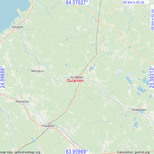
Oulainen GPS coordinates[2]
64° 16' 0.012" North, 24° 48' 0" East
| Map corner | latitude | longitude |
|---|---|---|
| Upper-left | 64.57027°, | 24.09688° |
| Center: | 64.26667°, | 24.8° |
| Lower-right: | 63.95969°, | 25.50313° |
| Map W x H: | 67.9×67.9 km | = 42.2×42.2mi |
| max Lat: | 69.90864° ⇑12.4% North |
| Oulainen: | 64.26667° |
| min Lat: | ⇓87.6% South 59.83333° |
| min Long | Oulainen | max Long |
| 21.2° | 24.8° | 30.93276° |
| W 51.1%⇐ | ⇒48.9% E |
Elevation
Elevation of Oulainen is 72 m = 236 ft, and this is 5.1 m = 17 ft below average elevation for this country.
| Max E: |
299 m = 981 ft | 55.8% |
| Avg. | 77.1 m = 253 ft | |
| Oulainen | 72 m = 236 ft | |
Min E: |
1 m = 3 ft | 44.2% |
See also: Finland elevation on elevation.city.
Geographical zone
Oulainen is located in North temperate zone (between Tropic of Cancer and the Arctic Circle). Distance of this North polar circle is 255.4 km =158.7 mi to North.| Distance of | km | miles | from Oulainen |
|---|---|---|---|
| North Pole | 2861.3 | 1777.9 | to North |
| Arctic Circle | 255.4 | 158.7 | to North |
| Tropic Cancer | 4539.9 | 2821 | to South |
| Equator | 7145.8 | 4440.2 | to South |


Nearby cities:
15 places around Oulainen: (largest is in red/bold)
• Alavieska
26.6 km =16.5 mi,  245°
245°
• Haapavesi
31.2 km =19.4 mi,  118°
118°
• Kalajoki
41.1 km =25.5 mi,  267°
267°
• Kärsämäki
57.6 km =35.8 mi,  125°
125°
• Merijärvi
17.3 km =10.7 mi,  282°
282°
• Nivala
39.7 km =24.7 mi,  168°
168°
• Piippola
57.5 km =35.7 mi,  101°
101°
• Pulkkila
51.5 km =32 mi,  90°
90°
• Pyhäjoki
35.2 km =21.9 mi,  309°
309°
• Raahe
48.7 km =30.3 mi,  341°
341°
• Rantsila
49.4 km =30.7 mi,  57°
57°
• Ruukki
46.7 km =29 mi,  17°
17°
• Sievi
43.3 km =26.9 mi,  199°
199°
• Vihanti
25.9 km =16.1 mi, 20°
• Ylivieska
23.7 km =14.7 mi,  210°
210°
Sources, notices
• [Note1] Compared only with cities in Finland existing in our database
• [Src1] Map data: © OpenStreetMap contributors (CC-BY-SA)
• [Src2] Other city data from geonames.org with taken over terms of usage.
• [Src3] Geographical zone / Annual Mean Temperature by Robert A. Rohde @ Wikipedia
