Enonkoski geodata
Enonkoski (South Savo) is a seat of a third-order administrative division; located in Finland in Europe/Helsinki (GMT+3) time zone. With population of 1,714 people, there are 377 cities with bigger population in this country. Compared to other cities in Finland, 54.1% of cities are located further ↓South; 94.2% of cities are located further ←West and 67.5% of cities have lower elevation than Enonkoski. Note1


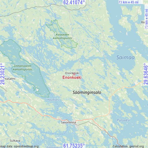
Enonkoski GPS coordinates[2]
62° 4' 59.988" North, 28° 55' 59.988" East
| Map corner | latitude | longitude |
|---|---|---|
| Upper-left | 62.41074°, | 28.23021° |
| Center: | 62.08333°, | 28.93333° |
| Lower-right: | 61.75235°, | 29.63646° |
| Map W x H: | 73.2×73.2 km | = 45.5×45.5mi |
| max Lat: | 69.90864° ⇑45.9% North |
| Enonkoski: | 62.08333° |
| min Lat: | ⇓54.1% South 59.83333° |
| min Long | Enonkoski | max Long |
| 21.2° | 28.93333° | 30.93276° |
| W 94.2%⇐ | ⇒5.8% E |
Elevation
Elevation of Enonkoski is 103 m = 338 ft, and this is 25.9 m = 85 ft above average elevation for this country.
| Max E: |
299 m = 981 ft | 32.5% |
| Enonkoski | 103 m 338 ft | |
| Avg. | 77.1 m = 253 ft | |
Min E: |
1 m = 3 ft | 67.5% |
See also: Finland elevation on elevation.city.
Geographical zone
Enonkoski is located in North temperate zone (between Tropic of Cancer and the Arctic Circle). Distance of this North polar circle is 498.2 km =309.6 mi to North.| Distance of | km | miles | from Enonkoski |
|---|---|---|---|
| North Pole | 3104 | 1928.7 | to North |
| Arctic Circle | 498.2 | 309.6 | to North |
| Tropic Cancer | 4297.1 | 2670.1 | to South |
| Equator | 6903 | 4289.3 | to South |


Nearby cities:
15 places around Enonkoski: (largest is in red/bold)
• Heinävesi
42.6 km =26.5 mi,  336°
336°
• Joroinen
58.2 km =36.2 mi,  280°
280°
• Juva
60.1 km =37.3 mi,  250°
250°
• Kangaslampi
42.5 km =26.4 mi,  303°
303°
• Kerimäki
26.5 km =16.5 mi,  136°
136°
• Kesälahti
51.4 km =31.9 mi,  113°
113°
• Kitee
63.3 km =39.3 mi,  88°
88°
• Liperi
54.8 km =34.1 mi,  24°
24°
• Punkaharju
43.2 km =26.8 mi,  146°
146°
• Rantasalmi
33 km =20.5 mi,  266°
266°
• Rääkkylä
43.9 km =27.3 mi,  53°
53°
• Savonlinna
23.9 km =14.9 mi,  186°
186°
• Savonranta
17.8 km =11.1 mi, 51°
• Sulkava
44.1 km =27.4 mi,  221°
221°
• Varkaus
60.7 km =37.7 mi, 295°
Sources, notices
• [Note1] Compared only with cities in Finland existing in our database
• [Src1] Map data: © OpenStreetMap contributors (CC-BY-SA)
• [Src2] Other city data from geonames.org with taken over terms of usage.
• [Src3] Geographical zone / Annual Mean Temperature by Robert A. Rohde @ Wikipedia
