Savonranta geodata
Savonranta (South Savo) is a seat of a third-order administrative division; located in Finland in Europe/Helsinki (GMT+3) time zone. With population of 1,255 people, there are 412 cities with bigger population in this country. Compared to other cities in Finland, 56% of cities are located further ↓South; 95.1% of cities are located further ←West and 51.1% of cities have higher elevation than Savonranta. Note1


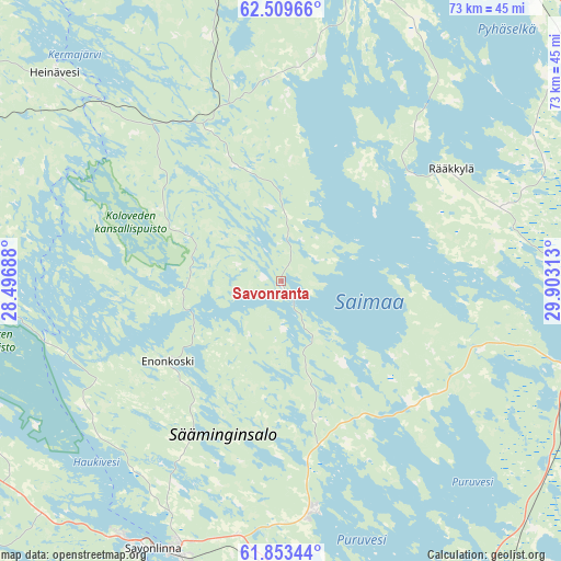
Savonranta GPS coordinates[2]
62° 10' 59.988" North, 29° 12' 0" East
| Map corner | latitude | longitude |
|---|---|---|
| Upper-left | 62.50966°, | 28.49688° |
| Center: | 62.18333°, | 29.2° |
| Lower-right: | 61.85344°, | 29.90313° |
| Map W x H: | 73×73 km | = 45.4×45.4mi |
| max Lat: | 69.90864° ⇑44% North |
| Savonranta: | 62.18333° |
| min Lat: | ⇓56% South 59.83333° |
| min Long | Savonranta | max Long |
| 21.2° | 29.2° | 30.93276° |
| W 95.1%⇐ | ⇒4.9% E |
Elevation
Elevation of Savonranta is 79 m = 259 ft, and this is 1.9 m = 6 ft above average elevation for this country.
| Max E: |
299 m = 981 ft | 51.1% |
| Savonranta | 79 m 259 ft | |
| Avg. | 77.1 m = 253 ft | |
Min E: |
1 m = 3 ft | 48.9% |
See also: Finland elevation on elevation.city.
Geographical zone
Savonranta is located in North temperate zone (between Tropic of Cancer and the Arctic Circle). Distance of this North polar circle is 487 km =302.6 mi to North.| Distance of | km | miles | from Savonranta |
|---|---|---|---|
| North Pole | 3092.9 | 1921.8 | to North |
| Arctic Circle | 487 | 302.6 | to North |
| Tropic Cancer | 4308.2 | 2677 | to South |
| Equator | 6914.1 | 4296.2 | to South |


Nearby cities:
15 places around Savonranta: (largest is in red/bold)
• Enonkoski
17.8 km =11.1 mi,  231°
231°
• Heinävesi
41.6 km =25.8 mi,  311°
311°
• Joensuu
54.8 km =34.1 mi,  31°
31°
• Kangaslampi
50.6 km =31.4 mi,  284°
284°
• Kerimäki
30.6 km =19 mi,  171°
171°
• Kesälahti
45.9 km =28.5 mi,  133°
133°
• Kitee
50.2 km =31.2 mi,  100°
100°
• Liperi
39.9 km =24.8 mi,  12°
12°
• Outokumpu
61.2 km =38 mi,  351°
351°
• Punkaharju
48.2 km =30 mi, 168°
• Pyhäselkä
48.4 km =30.1 mi,  54°
54°
• Rantasalmi
48.6 km =30.2 mi,  254°
254°
• Rääkkylä
26.2 km =16.3 mi,  55°
55°
• Savonlinna
38.6 km =24 mi,  205°
205°
• Uukuniemi
61 km =37.9 mi,  136°
136°
Sources, notices
• [Note1] Compared only with cities in Finland existing in our database
• [Src1] Map data: © OpenStreetMap contributors (CC-BY-SA)
• [Src2] Other city data from geonames.org with taken over terms of usage.
• [Src3] Geographical zone / Annual Mean Temperature by Robert A. Rohde @ Wikipedia
