Orimattila geodata
Orimattila (Päijänne Tavastia) is a seat of a third-order administrative division; located in Finland in Europe/Helsinki (GMT+3) time zone. With population of 14,603 people, there are 76 cities with bigger population in this country. Compared to other cities in Finland, 74.4% of cities are located further ↑North; 67.1% of cities are located further ←West and 52.6% of cities have higher elevation than Orimattila. Note1


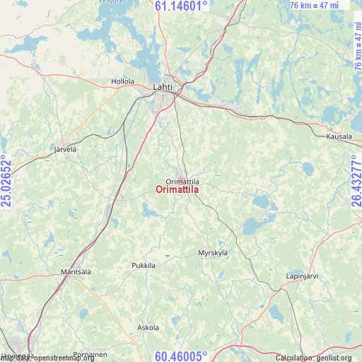
Orimattila GPS coordinates[2]
60° 48' 17.532" North, 25° 43' 46.704" East
| Map corner | latitude | longitude |
|---|---|---|
| Upper-left | 61.14601°, | 25.02652° |
| Center: | 60.80487°, | 25.72964° |
| Lower-right: | 60.46005°, | 26.43277° |
| Map W x H: | 76.3×76.3 km | = 47.4×47.4mi |
| max Lat: | 69.90864° ⇑74.4% North |
| Orimattila: | 60.80487° |
| min Lat: | ⇓25.6% South 59.83333° |
| min Long | Orimattila | max Long |
| 21.2° | 25.72964° | 30.93276° |
| W 67.1%⇐ | ⇒32.9% E |
Elevation
Elevation of Orimattila is 76 m = 249 ft, and this is 1.1 m = 4 ft below average elevation for this country.
| Max E: |
299 m = 981 ft | 52.6% |
| Avg. | 77.1 m = 253 ft | |
| Orimattila | 76 m = 249 ft | |
Min E: |
1 m = 3 ft | 47.4% |
See also: Finland elevation on elevation.city.
Geographical zone
Orimattila is located in North temperate zone (between Tropic of Cancer and the Arctic Circle). Distance of this North polar circle is 640.3 km =397.9 mi to North.| Distance of | km | miles | from Orimattila |
|---|---|---|---|
| North Pole | 3246.2 | 2017.1 | to North |
| Arctic Circle | 640.3 | 397.9 | to North |
| Tropic Cancer | 4154.9 | 2581.7 | to South |
| Equator | 6760.9 | 4201 | to South |


Nearby cities:
15 places around Orimattila: (largest is in red/bold)
• Artjärvi
19.7 km =12.2 mi,  109°
109°
• Askola
31 km =19.3 mi,  193°
193°
• Hollola
25 km =15.5 mi,  330°
330°
• Hollola
31.6 km =19.6 mi, 329°
• Iitti
34.5 km =21.4 mi,  73°
73°
• Järvelä
25.1 km =15.6 mi,  285°
285°
• Kärkölä
28.8 km =17.9 mi,  295°
295°
• Lahti
20.1 km =12.5 mi,  349°
349°
• Lapinjärvi
32.4 km =20.1 mi,  128°
128°
• Liljendal
31.2 km =19.4 mi,  145°
145°
• Myrskylä
16.3 km =10.1 mi,  156°
156°
• Mäntsälä
29.5 km =18.3 mi,  229°
229°
• Nastola
19.5 km =12.1 mi,  34°
34°
• Oitti
37.9 km =23.5 mi,  266°
266°
• Pukkila
19.4 km =12.1 mi,  207°
207°
Sources, notices
• [Note1] Compared only with cities in Finland existing in our database
• [Src1] Map data: © OpenStreetMap contributors (CC-BY-SA)
• [Src2] Other city data from geonames.org with taken over terms of usage.
• [Src3] Geographical zone / Annual Mean Temperature by Robert A. Rohde @ Wikipedia
