Hollola geodata
Hollola (Päijänne Tavastia) is a seat of a third-order administrative division; located in Finland in Europe/Helsinki (GMT+3) time zone. In our database, there are 443 cities with bigger population. Compared to other cities in Finland, 69.2% of cities are located further ↑North; 63.7% of cities are located further ←West and 89.7% of cities have lower elevation than Hollola. Note1


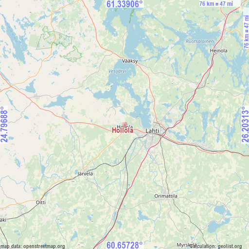
Hollola GPS coordinates[2]
61° 0' 0" North, 25° 30' 0" East
| Map corner | latitude | longitude |
|---|---|---|
| Upper-left | 61.33906°, | 24.79688° |
| Center: | 61°, | 25.5° |
| Lower-right: | 60.65728°, | 26.20313° |
| Map W x H: | 75.8×75.8 km | = 47.1×47.1mi |
| max Lat: | 69.90864° ⇑69.2% North |
| Hollola: | 61° |
| min Lat: | ⇓30.8% South 59.83333° |
| min Long | Hollola | max Long |
| 21.2° | 25.5° | 30.93276° |
| W 63.7%⇐ | ⇒36.3% E |
Elevation
Elevation of Hollola is 140 m = 459 ft, and this is 62.9 m = 206 ft above average elevation for this country.
| Max E: |
299 m = 981 ft | 10.3% |
| Hollola | 140 m 459 ft | |
| Avg. | 77.1 m = 253 ft | |
Min E: |
1 m = 3 ft | 89.7% |
See also: Finland elevation on elevation.city.
Geographical zone
Hollola is located in North temperate zone (between Tropic of Cancer and the Arctic Circle). Distance of this North polar circle is 618.6 km =384.4 mi to North.| Distance of | km | miles | from Hollola |
|---|---|---|---|
| North Pole | 3224.5 | 2003.6 | to North |
| Arctic Circle | 618.6 | 384.4 | to North |
| Tropic Cancer | 4176.6 | 2595.2 | to South |
| Equator | 6782.6 | 4214.5 | to South |


Nearby cities:
15 places around Hollola: (largest is in red/bold)
• Asikkala
24.1 km =15 mi,  0°
0°
• Auttoinen
39.9 km =24.8 mi,  326°
326°
• Hausjärvi
39 km =24.2 mi,  231°
231°
• Heinola
36.9 km =22.9 mi,  51°
51°
• Hollola
6.6 km =4.1 mi, 327°
• Hämeenkoski
18.8 km =11.7 mi,  277°
277°
• Järvelä
18.9 km =11.7 mi,  218°
218°
• Kärkölä
16.4 km =10.2 mi,  235°
235°
• Lahti
8.9 km =5.5 mi,  102°
102°
• Lammi
27.6 km =17.1 mi,  289°
289°
• Nastola
24 km =14.9 mi, 103°
• Oitti
34.9 km =21.7 mi, 226°
• Orimattila
25 km =15.5 mi,  150°
150°
• Padasjoki
40.6 km =25.2 mi,  343°
343°
• Pukkila
39.1 km =24.3 mi,  174°
174°
Sources, notices
• [Note1] Compared only with cities in Finland existing in our database
• [Src1] Map data: © OpenStreetMap contributors (CC-BY-SA)
• [Src2] Other city data from geonames.org with taken over terms of usage.
• [Src3] Geographical zone / Annual Mean Temperature by Robert A. Rohde @ Wikipedia
