Iitti geodata
Iitti (Kymenlaakso) is a seat of a third-order administrative division; located in Finland in Europe/Helsinki (GMT+3) time zone. With population of 7,246 people, there are 153 cities with bigger population in this country. Compared to other cities in Finland, 72.2% of cities are located further ↑North; 73.9% of cities are located further ←West and 50.6% of cities have higher elevation than Iitti. Note1


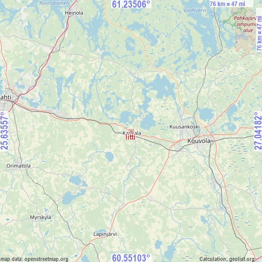
Iitti GPS coordinates[2]
60° 53' 41.568" North, 26° 20' 19.284" East
| Map corner | latitude | longitude |
|---|---|---|
| Upper-left | 61.23506°, | 25.63557° |
| Center: | 60.89488°, | 26.33869° |
| Lower-right: | 60.55103°, | 27.04182° |
| Map W x H: | 76.1×76.1 km | = 47.3×47.3mi |
| max Lat: | 69.90864° ⇑72.2% North |
| Iitti: | 60.89488° |
| min Lat: | ⇓27.8% South 59.83333° |
| min Long | Iitti | max Long |
| 21.2° | 26.33869° | 30.93276° |
| W 73.9%⇐ | ⇒26.1% E |
Elevation
Elevation of Iitti is 80 m = 262 ft, and this is 2.9 m = 10 ft above average elevation for this country.
| Max E: |
299 m = 981 ft | 50.6% |
| Iitti | 80 m 262 ft | |
| Avg. | 77.1 m = 253 ft | |
Min E: |
1 m = 3 ft | 49.4% |
See also: Finland elevation on elevation.city.
Geographical zone
Iitti is located in North temperate zone (between Tropic of Cancer and the Arctic Circle). Distance of this North polar circle is 630.3 km =391.7 mi to North.| Distance of | km | miles | from Iitti |
|---|---|---|---|
| North Pole | 3236.2 | 2010.9 | to North |
| Arctic Circle | 630.3 | 391.7 | to North |
| Tropic Cancer | 4165 | 2588 | to South |
| Equator | 6770.9 | 4207.2 | to South |


Nearby cities:
15 places around Iitti: (largest is in red/bold)
• Anjala
35.7 km =22.2 mi,  131°
131°
• Artjärvi
22.1 km =13.7 mi,  221°
221°
• Elimäki
21 km =13 mi,  160°
160°
• Heinola
38.2 km =23.7 mi,  334°
334°
• Hollola
46.8 km =29.1 mi,  284°
284°
• Jaala
19.1 km =11.9 mi,  23°
23°
• Kouvola
19.8 km =12.3 mi,  99°
99°
• Lahti
37.9 km =23.5 mi, 284°
• Lapinjärvi
31 km =19.3 mi,  194°
194°
• Liljendal
39 km =24.2 mi,  203°
203°
• Myrskylä
36.6 km =22.7 mi,  226°
226°
• Nastola
22.7 km =14.1 mi,  285°
285°
• Orimattila
34.5 km =21.4 mi,  253°
253°
• Pyhtää
46 km =28.6 mi,  165°
165°
• Ruotsinpyhtää
41.5 km =25.8 mi, 170°
Sources, notices
• [Note1] Compared only with cities in Finland existing in our database
• [Src1] Map data: © OpenStreetMap contributors (CC-BY-SA)
• [Src2] Other city data from geonames.org with taken over terms of usage.
• [Src3] Geographical zone / Annual Mean Temperature by Robert A. Rohde @ Wikipedia
