Mäntyharju geodata
Mäntyharju (South Savo) is a seat of a third-order administrative division; located in Finland in Europe/Helsinki (GMT+3) time zone. With population of 6,871 people, there are 160 cities with bigger population in this country. Compared to other cities in Finland, 59% of cities are located further ↑North; 78.6% of cities are located further ←West and 54.9% of cities have lower elevation than Mäntyharju. Note1


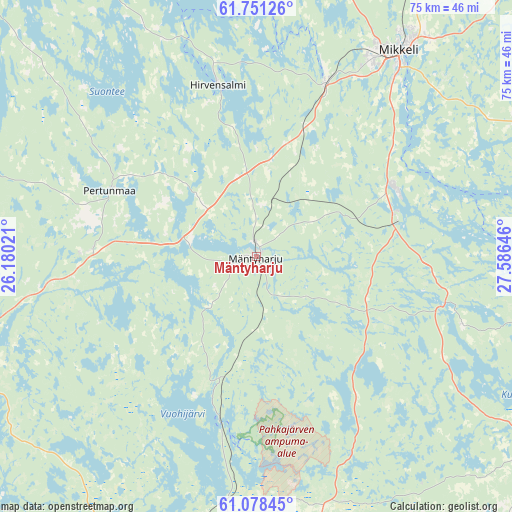
Mäntyharju GPS coordinates[2]
61° 25' 0.012" North, 26° 52' 59.988" East
| Map corner | latitude | longitude |
|---|---|---|
| Upper-left | 61.75126°, | 26.18021° |
| Center: | 61.41667°, | 26.88333° |
| Lower-right: | 61.07845°, | 27.58646° |
| Map W x H: | 74.8×74.8 km | = 46.5×46.5mi |
| max Lat: | 69.90864° ⇑59% North |
| Mäntyharju: | 61.41667° |
| min Lat: | ⇓41% South 59.83333° |
| min Long | Mäntyharju | max Long |
| 21.2° | 26.88333° | 30.93276° |
| W 78.6%⇐ | ⇒21.4% E |
Elevation
Elevation of Mäntyharju is 86 m = 282 ft, and this is 8.9 m = 29 ft above average elevation for this country.
| Max E: |
299 m = 981 ft | 45.1% |
| Mäntyharju | 86 m 282 ft | |
| Avg. | 77.1 m = 253 ft | |
Min E: |
1 m = 3 ft | 54.9% |
See also: Finland elevation on elevation.city.
Geographical zone
Mäntyharju is located in North temperate zone (between Tropic of Cancer and the Arctic Circle). Distance of this North polar circle is 572.3 km =355.6 mi to North.| Distance of | km | miles | from Mäntyharju |
|---|---|---|---|
| North Pole | 3178.2 | 1974.8 | to North |
| Arctic Circle | 572.3 | 355.6 | to North |
| Tropic Cancer | 4223 | 2624 | to South |
| Equator | 6828.9 | 4243.3 | to South |


Nearby cities:
15 places around Mäntyharju: (largest is in red/bold)
• Hartola
49.6 km =30.8 mi,  291°
291°
• Heinola
50.9 km =31.6 mi,  242°
242°
• Hirvensalmi
24.5 km =15.2 mi,  349°
349°
• Iitti
65 km =40.4 mi,  206°
206°
• Jaala
45.9 km =28.5 mi, 207°
• Joutsa
53.7 km =33.4 mi,  310°
310°
• Kangasniemi
65.3 km =40.6 mi, 349°
• Kouvola
61.9 km =38.5 mi,  189°
189°
• Lemi
63.1 km =39.2 mi,  128°
128°
• Mikkeli
36.6 km =22.7 mi,  34°
34°
• Pertunmaa
23.2 km =14.4 mi, 293°
• Ristiina
21.7 km =13.5 mi,  62°
62°
• Savitaipale
49.8 km =30.9 mi,  118°
118°
• Suomenniemi
31.6 km =19.6 mi,  108°
108°
• Sysmä
64.4 km =40 mi,  278°
278°
Sources, notices
• [Note1] Compared only with cities in Finland existing in our database
• [Src1] Map data: © OpenStreetMap contributors (CC-BY-SA)
• [Src2] Other city data from geonames.org with taken over terms of usage.
• [Src3] Geographical zone / Annual Mean Temperature by Robert A. Rohde @ Wikipedia
