Joutsa geodata
Joutsa (Central Finland) is a seat of a third-order administrative division; located in Finland in Europe/Helsinki (GMT+3) time zone. With population of 4,060 people, there are 245 cities with bigger population in this country. Compared to other cities in Finland, 51.9% of cities are located further ↑North; 72.2% of cities are located further ←West and 86.8% of cities have lower elevation than Joutsa. Note1


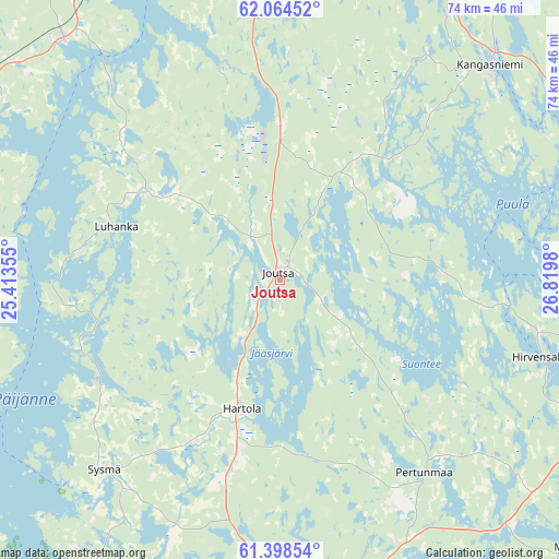
Joutsa GPS coordinates[2]
61° 43' 59.988" North, 26° 7' 0.012" East
| Map corner | latitude | longitude |
|---|---|---|
| Upper-left | 62.06452°, | 25.41355° |
| Center: | 61.73333°, | 26.11667° |
| Lower-right: | 61.39854°, | 26.8198° |
| Map W x H: | 74.1×74 km | = 46×46mi |
| max Lat: | 69.90864° ⇑51.9% North |
| Joutsa: | 61.73333° |
| min Lat: | ⇓48.1% South 59.83333° |
| min Long | Joutsa | max Long |
| 21.2° | 26.11667° | 30.93276° |
| W 72.2%⇐ | ⇒27.8% E |
Elevation
Elevation of Joutsa is 132 m = 433 ft, and this is 54.9 m = 180 ft above average elevation for this country.
| Max E: |
299 m = 981 ft | 13.2% |
| Joutsa | 132 m 433 ft | |
| Avg. | 77.1 m = 253 ft | |
Min E: |
1 m = 3 ft | 86.8% |
See also: Finland elevation on elevation.city.
Geographical zone
Joutsa is located in North temperate zone (between Tropic of Cancer and the Arctic Circle). Distance of this North polar circle is 537.1 km =333.7 mi to North.| Distance of | km | miles | from Joutsa |
|---|---|---|---|
| North Pole | 3143 | 1953 | to North |
| Arctic Circle | 537.1 | 333.7 | to North |
| Tropic Cancer | 4258.2 | 2645.9 | to South |
| Equator | 6864.1 | 4265.2 | to South |


Nearby cities:
15 places around Joutsa: (largest is in red/bold)
• Hartola
17.5 km =10.9 mi,  197°
197°
• Hirvensalmi
37.7 km =23.4 mi,  107°
107°
• Jämsä
50.8 km =31.6 mi,  286°
286°
• Jämsänkoski
53.8 km =33.4 mi, 292°
• Kangasniemi
40.2 km =25 mi,  43°
43°
• Korpilahti
43.3 km =26.9 mi,  316°
316°
• Kuhmoinen
52.6 km =32.7 mi,  249°
249°
• Leivonmäki
19.9 km =12.4 mi,  1°
1°
• Luhanka
22.8 km =14.2 mi, 288°
• Muurame
50.3 km =31.3 mi,  332°
332°
• Mäntyharju
53.7 km =33.4 mi,  130°
130°
• Pertunmaa
32.4 km =20.1 mi,  143°
143°
• Sysmä
34.6 km =21.5 mi,  221°
221°
• Säynätsalo
48.8 km =30.3 mi,  338°
338°
• Toivakka
40.8 km =25.4 mi,  357°
357°
Sources, notices
• [Note1] Compared only with cities in Finland existing in our database
• [Src1] Map data: © OpenStreetMap contributors (CC-BY-SA)
• [Src2] Other city data from geonames.org with taken over terms of usage.
• [Src3] Geographical zone / Annual Mean Temperature by Robert A. Rohde @ Wikipedia
