Kuhmoinen geodata
Kuhmoinen (Central Finland) is a seat of a third-order administrative division; located in Finland in Europe/Helsinki (GMT+3) time zone. With population of 2,824 people, there are 311 cities with bigger population in this country. Compared to other cities in Finland, 54.5% of cities are located further ↑North; 58.5% of cities are located further ←West and 72% of cities have lower elevation than Kuhmoinen. Note1


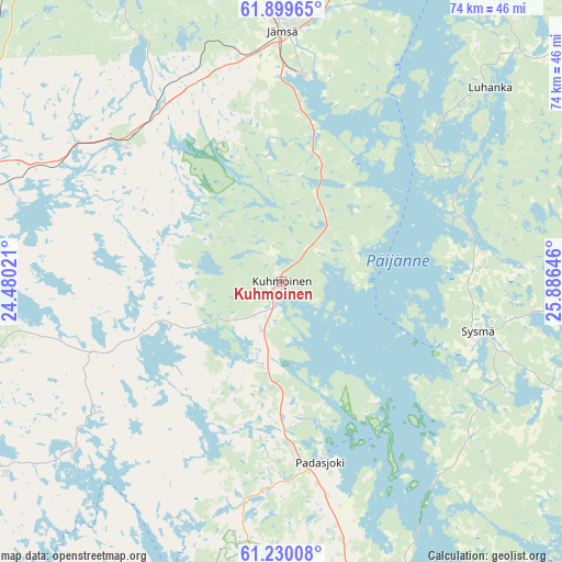
Kuhmoinen GPS coordinates[2]
61° 34' 0.012" North, 25° 10' 59.988" East
| Map corner | latitude | longitude |
|---|---|---|
| Upper-left | 61.89965°, | 24.48021° |
| Center: | 61.56667°, | 25.18333° |
| Lower-right: | 61.23008°, | 25.88646° |
| Map W x H: | 74.4×74.4 km | = 46.2×46.2mi |
| max Lat: | 69.90864° ⇑54.5% North |
| Kuhmoinen: | 61.56667° |
| min Lat: | ⇓45.5% South 59.83333° |
| min Long | Kuhmoinen | max Long |
| 21.2° | 25.18333° | 30.93276° |
| W 58.5%⇐ | ⇒41.5% E |
Elevation
Elevation of Kuhmoinen is 108 m = 354 ft, and this is 30.9 m = 101 ft above average elevation for this country.
| Max E: |
299 m = 981 ft | 28% |
| Kuhmoinen | 108 m 354 ft | |
| Avg. | 77.1 m = 253 ft | |
Min E: |
1 m = 3 ft | 72% |
See also: Finland elevation on elevation.city.
Geographical zone
Kuhmoinen is located in North temperate zone (between Tropic of Cancer and the Arctic Circle). Distance of this North polar circle is 555.6 km =345.2 mi to North.| Distance of | km | miles | from Kuhmoinen |
|---|---|---|---|
| North Pole | 3161.5 | 1964.5 | to North |
| Arctic Circle | 555.6 | 345.2 | to North |
| Tropic Cancer | 4239.7 | 2634.4 | to South |
| Equator | 6845.6 | 4253.7 | to South |


Nearby cities:
15 places around Kuhmoinen: (largest is in red/bold)
• Asikkala
42.4 km =26.3 mi,  156°
156°
• Auttoinen
30.2 km =18.8 mi,  189°
189°
• Hartola
44.1 km =27.4 mi,  87°
87°
• Joutsa
52.6 km =32.7 mi,  69°
69°
• Juupajoki
50.1 km =31.1 mi,  301°
301°
• Jämsä
33.1 km =20.6 mi,  0°
0°
• Jämsänkoski
39.2 km =24.4 mi,  358°
358°
• Kuhmalahti
33.5 km =20.8 mi,  257°
257°
• Luhanka
37.6 km =23.4 mi,  47°
47°
• Luopioinen
35.5 km =22.1 mi,  230°
230°
• Orivesi
45.4 km =28.2 mi,  285°
285°
• Padasjoki
24.7 km =15.3 mi,  167°
167°
• Sahalahti
46.6 km =29 mi, 257°
• Sysmä
27.5 km =17.1 mi,  105°
105°
• Tuulos
50.6 km =31.4 mi,  203°
203°
Sources, notices
• [Note1] Compared only with cities in Finland existing in our database
• [Src1] Map data: © OpenStreetMap contributors (CC-BY-SA)
• [Src2] Other city data from geonames.org with taken over terms of usage.
• [Src3] Geographical zone / Annual Mean Temperature by Robert A. Rohde @ Wikipedia
