Jämsä geodata
Jämsä (Central Finland) is a seat of a third-order administrative division; located in Finland in Europe/Helsinki (GMT+3) time zone. With population of 15,261 people, there are 72 cities with bigger population in this country. Compared to other cities in Finland, 50.2% of cities are located further ↓South; 59.2% of cities are located further ←West and 51.5% of cities have lower elevation than Jämsä. Note1


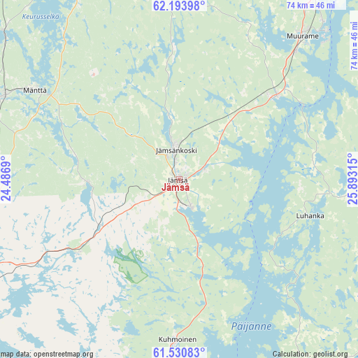
Jämsä GPS coordinates[2]
61° 51' 51.12" North, 25° 11' 24.072" East
| Map corner | latitude | longitude |
|---|---|---|
| Upper-left | 62.19398°, | 24.4869° |
| Center: | 61.8642°, | 25.19002° |
| Lower-right: | 61.53083°, | 25.89315° |
| Map W x H: | 73.7×73.7 km | = 45.8×45.8mi |
| max Lat: | 69.90864° ⇑49.8% North |
| Jämsä: | 61.8642° |
| min Lat: | ⇓50.2% South 59.83333° |
| min Long | Jämsä | max Long |
| 21.2° | 25.19002° | 30.93276° |
| W 59.2%⇐ | ⇒40.8% E |
Elevation
Elevation of Jämsä is 83 m = 272 ft, and this is 5.9 m = 19 ft above average elevation for this country.
| Max E: |
299 m = 981 ft | 48.5% |
| Jämsä | 83 m 272 ft | |
| Avg. | 77.1 m = 253 ft | |
Min E: |
1 m = 3 ft | 51.5% |
See also: Finland elevation on elevation.city.
Geographical zone
Jämsä is located in North temperate zone (between Tropic of Cancer and the Arctic Circle). Distance of this North polar circle is 522.5 km =324.7 mi to North.| Distance of | km | miles | from Jämsä |
|---|---|---|---|
| North Pole | 3128.4 | 1943.9 | to North |
| Arctic Circle | 522.5 | 324.7 | to North |
| Tropic Cancer | 4272.7 | 2654.9 | to South |
| Equator | 6878.7 | 4274.2 | to South |


Nearby cities:
15 places around Jämsä: (largest is in red/bold)
• Joutsa
50.8 km =31.6 mi,  106°
106°
• Juupajoki
43.7 km =27.2 mi,  260°
260°
• Jyväskylä
50.2 km =31.2 mi,  33°
33°
• Jämsänkoski
6.2 km =3.9 mi,  350°
350°
• Korpilahti
25.3 km =15.7 mi,  47°
47°
• Kuhmoinen
33.1 km =20.6 mi,  180°
180°
• Leivonmäki
49.4 km =30.7 mi,  83°
83°
• Luhanka
28 km =17.4 mi, 105°
• Muurame
38.9 km =24.2 mi,  39°
39°
• Mänttä
34.7 km =21.6 mi,  302°
302°
• Orivesi
48.5 km =30.1 mi,  244°
244°
• Petäjävesi
42.9 km =26.7 mi,  0°
0°
• Sysmä
48.1 km =29.9 mi,  147°
147°
• Säynätsalo
43.1 km =26.8 mi, 44°
• Vilppula
39.9 km =24.8 mi, 295°
Sources, notices
• [Note1] Compared only with cities in Finland existing in our database
• [Src1] Map data: © OpenStreetMap contributors (CC-BY-SA)
• [Src2] Other city data from geonames.org with taken over terms of usage.
• [Src3] Geographical zone / Annual Mean Temperature by Robert A. Rohde @ Wikipedia
