Padasjoki geodata
Padasjoki (Päijänne Tavastia) is a seat of a third-order administrative division; located in Finland in Europe/Helsinki (GMT+3) time zone. With population of 3,473 people, there are 272 cities with bigger population in this country. Compared to other cities in Finland, 59.8% of cities are located further ↑North; 60.7% of cities are located further ←West and 76.3% of cities have lower elevation than Padasjoki. Note1


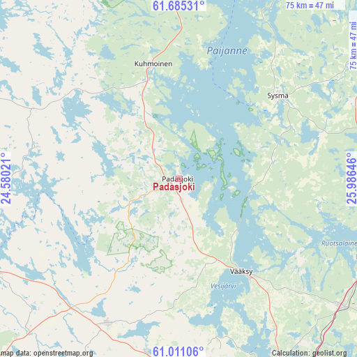
Padasjoki GPS coordinates[2]
61° 21' 0" North, 25° 16' 59.988" East
| Map corner | latitude | longitude |
|---|---|---|
| Upper-left | 61.68531°, | 24.58021° |
| Center: | 61.35°, | 25.28333° |
| Lower-right: | 61.01106°, | 25.98646° |
| Map W x H: | 75×75 km | = 46.6×46.6mi |
| max Lat: | 69.90864° ⇑59.8% North |
| Padasjoki: | 61.35° |
| min Lat: | ⇓40.2% South 59.83333° |
| min Long | Padasjoki | max Long |
| 21.2° | 25.28333° | 30.93276° |
| W 60.7%⇐ | ⇒39.3% E |
Elevation
Elevation of Padasjoki is 113 m = 371 ft, and this is 35.9 m = 118 ft above average elevation for this country.
| Max E: |
299 m = 981 ft | 23.7% |
| Padasjoki | 113 m 371 ft | |
| Avg. | 77.1 m = 253 ft | |
Min E: |
1 m = 3 ft | 76.3% |
See also: Finland elevation on elevation.city.
Geographical zone
Padasjoki is located in North temperate zone (between Tropic of Cancer and the Arctic Circle). Distance of this North polar circle is 579.7 km =360.2 mi to North.| Distance of | km | miles | from Padasjoki |
|---|---|---|---|
| North Pole | 3185.6 | 1979.4 | to North |
| Arctic Circle | 579.7 | 360.2 | to North |
| Tropic Cancer | 4215.6 | 2619.5 | to South |
| Equator | 6821.5 | 4238.7 | to South |


Nearby cities:
15 places around Padasjoki: (largest is in red/bold)
• Asikkala
18.8 km =11.7 mi,  142°
142°
• Auttoinen
11.8 km =7.3 mi,  241°
241°
• Hartola
46.8 km =29.1 mi,  56°
56°
• Hauho
43.3 km =26.9 mi, 242°
• Heinola
43.4 km =27 mi,  111°
111°
• Hollola
34.3 km =21.3 mi,  166°
166°
• Hollola
40.6 km =25.2 mi,  163°
163°
• Hämeenkoski
37.1 km =23.1 mi,  190°
190°
• Kuhmalahti
41.6 km =25.8 mi,  293°
293°
• Kuhmoinen
24.7 km =15.3 mi,  347°
347°
• Lahti
45.6 km =28.3 mi,  153°
153°
• Lammi
32.9 km =20.4 mi,  205°
205°
• Luopioinen
32.8 km =20.4 mi,  272°
272°
• Sysmä
27 km =16.8 mi,  51°
51°
• Tuulos
34.1 km =21.2 mi,  229°
229°
Sources, notices
• [Note1] Compared only with cities in Finland existing in our database
• [Src1] Map data: © OpenStreetMap contributors (CC-BY-SA)
• [Src2] Other city data from geonames.org with taken over terms of usage.
• [Src3] Geographical zone / Annual Mean Temperature by Robert A. Rohde @ Wikipedia
