Jalasjärvi geodata
Jalasjärvi (Southern Ostrobothnia) is a populated place; located in Finland in Europe/Helsinki (GMT+3) time zone. With population of 8,662 people, there are 129 cities with bigger population in this country. Compared to other cities in Finland, 61.8% of cities are located further ↓South; 78.8% of cities are located further →East and 59.4% of cities have lower elevation than Jalasjärvi. Note1


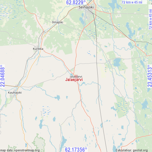
Jalasjärvi GPS coordinates[2]
62° 30' 0" North, 22° 45' 0" East
| Map corner | latitude | longitude |
|---|---|---|
| Upper-left | 62.8229°, | 22.04688° |
| Center: | 62.5°, | 22.75° |
| Lower-right: | 62.17356°, | 23.45313° |
| Map W x H: | 72.2×72.2 km | = 44.9×44.9mi |
| max Lat: | 69.90864° ⇑38.2% North |
| Jalasjärvi: | 62.5° |
| min Lat: | ⇓61.8% South 59.83333° |
| min Long | Jalasjärvi | max Long |
| 21.2° | 22.75° | 30.93276° |
| W 21.2%⇐ | ⇒78.8% E |
Elevation
Elevation of Jalasjärvi is 94 m = 308 ft, and this is 16.9 m = 55 ft above average elevation for this country.
| Max E: |
299 m = 981 ft | 40.6% |
| Jalasjärvi | 94 m 308 ft | |
| Avg. | 77.1 m = 253 ft | |
Min E: |
1 m = 3 ft | 59.4% |
See also: Finland elevation on elevation.city.
Geographical zone
Jalasjärvi is located in North temperate zone (between Tropic of Cancer and the Arctic Circle). Distance of this North polar circle is 451.8 km =280.7 mi to North.| Distance of | km | miles | from Jalasjärvi |
|---|---|---|---|
| North Pole | 3057.7 | 1900 | to North |
| Arctic Circle | 451.8 | 280.7 | to North |
| Tropic Cancer | 4343.4 | 2698.9 | to South |
| Equator | 6949.3 | 4318.1 | to South |


Nearby cities:
15 places around Jalasjärvi: (largest is in red/bold)
• Alavus
45.4 km =28.2 mi,  78°
78°
• Ilmajoki
27.6 km =17.1 mi,  340°
340°
• Jurva
44.2 km =27.5 mi,  297°
297°
• Karvia
33.8 km =21 mi,  188°
188°
• Karvia
41.9 km =26 mi, 193°
• Kauhajoki
30.1 km =18.7 mi,  255°
255°
• Kihniö
40.2 km =25 mi,  146°
146°
• Kuortane
50.8 km =31.6 mi,  48°
48°
• Kurikka
21.4 km =13.3 mi,  307°
307°
• Lapua
53.8 km =33.4 mi,  14°
14°
• Nurmo
37.4 km =23.2 mi, 12°
• Parkano
55.5 km =34.5 mi,  165°
165°
• Seinäjoki
33 km =20.5 mi, 6°
• Teuva
51.8 km =32.2 mi,  267°
267°
• Ylistaro
50.3 km =31.3 mi,  346°
346°
Sources, notices
• [Note1] Compared only with cities in Finland existing in our database
• [Src1] Map data: © OpenStreetMap contributors (CC-BY-SA)
• [Src2] Other city data from geonames.org with taken over terms of usage.
• [Src3] Geographical zone / Annual Mean Temperature by Robert A. Rohde @ Wikipedia
