Kullaa geodata
Kullaa (Satakunta) is a populated place; located in Finland in Europe/Helsinki (GMT+3) time zone. With population of 1,494 people, there are 393 cities with bigger population in this country. Compared to other cities in Finland, 57.3% of cities are located further ↑North; 88.2% of cities are located further →East and 72.2% of cities have higher elevation than Kullaa. Note1


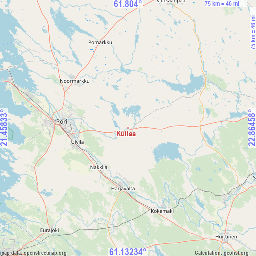
Kullaa GPS coordinates[2]
61° 28' 11.928" North, 22° 9' 41.22" East
| Map corner | latitude | longitude |
|---|---|---|
| Upper-left | 61.804°, | 21.45833° |
| Center: | 61.46998°, | 22.16145° |
| Lower-right: | 61.13234°, | 22.86458° |
| Map W x H: | 74.7×74.7 km | = 46.4×46.4mi |
| max Lat: | 69.90864° ⇑57.3% North |
| Kullaa: | 61.46998° |
| min Lat: | ⇓42.7% South 59.83333° |
| min Long | Kullaa | max Long |
| 21.2° | 22.16145° | 30.93276° |
| W 11.8%⇐ | ⇒88.2% E |
Elevation
Elevation of Kullaa is 35 m = 115 ft, and this is 42.1 m = 138 ft below average elevation for this country.
| Max E: |
299 m = 981 ft | 72.2% |
| Avg. | 77.1 m = 253 ft | |
| Kullaa | 35 m = 115 ft | |
Min E: |
1 m = 3 ft | 27.8% |
See also: Finland elevation on elevation.city.
Geographical zone
Kullaa is located in North temperate zone (between Tropic of Cancer and the Arctic Circle). Distance of this North polar circle is 566.4 km =351.9 mi to North.| Distance of | km | miles | from Kullaa |
|---|---|---|---|
| North Pole | 3172.2 | 1971.1 | to North |
| Arctic Circle | 566.4 | 351.9 | to North |
| Tropic Cancer | 4228.9 | 2627.7 | to South |
| Equator | 6834.8 | 4246.9 | to South |


Nearby cities:
15 places around Kullaa: (largest is in red/bold)
• Eura
37.5 km =23.3 mi,  182°
182°
• Harjavalta
17.1 km =10.6 mi,  185°
185°
• Kiikoinen
22.1 km =13.7 mi,  94°
94°
• Kiukainen
28.5 km =17.7 mi, 188°
• Kokemäki
25.9 km =16.1 mi,  156°
156°
• Lavia
27.4 km =17 mi,  58°
58°
• Luvia
30.9 km =19.2 mi,  247°
247°
• Längelmäki
20.3 km =12.6 mi,  350°
350°
• Nakkila
14.3 km =8.9 mi,  216°
216°
• Noormarkku
20.7 km =12.9 mi,  311°
311°
• Pomarkku
26.1 km =16.2 mi,  341°
341°
• Pori
20.1 km =12.5 mi,  274°
274°
• Suodenniemi
34.5 km =21.4 mi,  73°
73°
• Ulvila
16.1 km =10 mi, 253°
• Äetsä
34.7 km =21.6 mi,  126°
126°
Sources, notices
• [Note1] Compared only with cities in Finland existing in our database
• [Src1] Map data: © OpenStreetMap contributors (CC-BY-SA)
• [Src2] Other city data from geonames.org with taken over terms of usage.
• [Src3] Geographical zone / Annual Mean Temperature by Robert A. Rohde @ Wikipedia
