Ghyvelde geodata
Ghyvelde (Hauts-de-France) is a populated place; located in France in Europe/Paris (GMT+2) time zone. With population of 3,110 people, there are 3139 cities with bigger population in this country. Compared to other cities in France, 100% of cities are located further ↓South; 51% of cities are located further ←West and 99.9% of cities have higher elevation than Ghyvelde. Note1
Administrative division(s):
- Level 1: Hauts-de-France
- Level 2: Nord
- Level 3: Arrondissement de Dunkerque
- Level 4: Ghyvelde


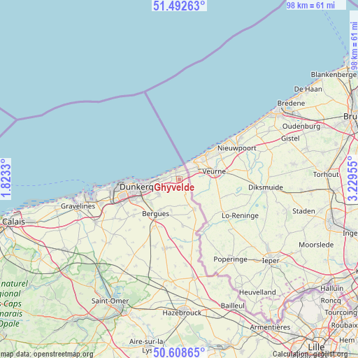
Ghyvelde GPS coordinates[2]
51° 3' 9.9" North, 2° 31' 35.112" East
| Map corner | latitude | longitude |
|---|---|---|
| Upper-left | 51.49263°, | 1.8233° |
| Center: | 51.05275°, | 2.52642° |
| Lower-right: | 50.60865°, | 3.22955° |
| Map W x H: | 98.3×98.3 km | = 61.1×61.1mi |
| max Lat: | 51.07786° ⇑0% North |
| Ghyvelde: | 51.05275° |
| min Lat: | ⇓100% South 41.3874° |
| min Long | Ghyvelde | max Long |
| -5.08615° | 2.52642° | 9.52242° |
| W 51%⇐ | ⇒49% E |
Elevation
Elevation of Ghyvelde is 2 m = 7 ft, and this is 191.7 m = 629 ft below average elevation for this country.
| Max E: |
2333 m = 7654 ft | 99.9% |
| Avg. | 193.7 m = 635 ft | |
| Ghyvelde | 2 m = 7 ft | |
Min E: |
-1 m = -3 ft | 0.1% |
See also: France elevation on elevation.city.
Geographical zone
Ghyvelde is located in North temperate zone (between Tropic of Cancer and the Arctic Circle). Distance of this North polar circle is 1724.6 km =1071.6 mi to North.| Distance of | km | miles | from Ghyvelde |
|---|---|---|---|
| North Pole | 4330.5 | 2690.8 | to North |
| Arctic Circle | 1724.6 | 1071.6 | to North |
| Tropic Cancer | 3070.6 | 1908 | to South |
| Equator | 5676.5 | 3527.2 | to South |


Nearby cities:
15 places around Ghyvelde: (largest is in red/bold)
• Bergues
11.4 km =7.1 mi,  215°
215°
• Bray-Dunes
2.9 km =1.8 mi,  346°
346°
• Coudekerque-Branche
9.9 km =6.2 mi,  250°
250°
• Coudekerque-Village
9.7 km =6 mi,  232°
232°
• Dunkerque
10.7 km =6.6 mi,  258°
258°
• Hondschoote
9.2 km =5.7 mi,  154°
154°
• Hoymille
10.6 km =6.6 mi,  211°
211°
• Killem
10.8 km =6.7 mi,  167°
167°
• Leffrinckoucke
4.8 km =3 mi,  244°
244°
• Les Moëres
4.5 km =2.8 mi,  159°
159°
• Rexpoëde
12.7 km =7.9 mi,  175°
175°
• Téteghem
6.9 km =4.3 mi, 236°
• Uxem
4.6 km =2.9 mi, 220°
• Warhem
8.9 km =5.5 mi,  195°
195°
• Zuydcoote
2.5 km =1.6 mi,  291°
291°
Sources, notices
• [Note1] Compared only with cities in France existing in our database
• [Src1] Map data: © OpenStreetMap contributors (CC-BY-SA)
• [Src2] Other city data from geonames.org with taken over terms of usage.
• [Src3] Geographical zone / Annual Mean Temperature by Robert A. Rohde @ Wikipedia
