Port-des-Barques geodata
Port-des-Barques (Nouvelle-Aquitaine) is a populated place; located in France in Europe/Paris (GMT+2) time zone. With population of 1,642 people, there are 5686 cities with bigger population in this country. Compared to other cities in France, 66.9% of cities are located further ↑North; 89% of cities are located further →East and 99.9% of cities have higher elevation than Port-des-Barques. Note1
Administrative division(s):
- Level 1: Nouvelle-Aquitaine
- Level 2: Charente-Maritime
- Level 3: Arrondissement de Rochefort
- Level 4: Port-des-Barques


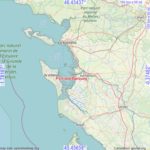
Port-des-Barques GPS coordinates[2]
45° 56' 51.468" North, 1° 4' 40.62" West
| Map corner | latitude | longitude |
|---|---|---|
| Upper-left | 46.43437°, | -1.78107° |
| Center: | 45.94763°, | -1.07795° |
| Lower-right: | 45.45658°, | -0.37482° |
| Map W x H: | 108.7×108.7 km | = 67.5×67.5mi |
| max Lat: | 51.07786° ⇑66.9% North |
| Port-des-Barques: | 45.94763° |
| min Lat: | ⇓33.1% South 41.3874° |
| min Long | Port-des-Barque | max Long |
| -5.08615° | -1.07795° | 9.52242° |
| W 11%⇐ | ⇒89% E |
Elevation
Elevation of Port-des-Barques is 2 m = 7 ft, and this is 191.7 m = 629 ft below average elevation for this country.
| Max E: |
2333 m = 7654 ft | 99.9% |
| Avg. | 193.7 m = 635 ft | |
| Port-des-Barques | 2 m = 7 ft | |
Min E: |
-1 m = -3 ft | 0.1% |
See also: France elevation on elevation.city.
Geographical zone
Port-des-Barques is located in North temperate zone (between Tropic of Cancer and the Arctic Circle). Distance of this North polar circle is 2292.3 km =1424.4 mi to North.| Distance of | km | miles | from Port-des-Barques |
|---|---|---|---|
| North Pole | 4898.2 | 3043.6 | to North |
| Arctic Circle | 2292.3 | 1424.4 | to North |
| Tropic Cancer | 2503 | 1555.3 | to South |
| Equator | 5108.9 | 3174.5 | to South |


Nearby cities:
15 places around Port-des-Barques: (largest is in red/bold)
• Bourcefranc-le-Chapus
12.2 km =7.6 mi,  207°
207°
• Boyard-Ville
12.9 km =8 mi,  279°
279°
• Breuil-Magné
10 km =6.2 mi,  65°
65°
• Châtelaillon-Plage
13.8 km =8.6 mi,  356°
356°
• Fouras
4.6 km =2.9 mi,  345°
345°
• Hiers-Brouage
11.1 km =6.9 mi,  178°
178°
• Moëze
5.9 km =3.7 mi,  145°
145°
• Rochefort
8.6 km =5.3 mi,  94°
94°
• Saint-Agnant
12.2 km =7.6 mi,  132°
132°
• Saint-Laurent-de-la-Prée
5 km =3.1 mi,  39°
39°
• Saint-Nazaire-sur-Charente
2.4 km =1.5 mi,  121°
121°
• Soubise
5.9 km =3.7 mi, 116°
• Vergeroux
7.6 km =4.7 mi, 73°
• Yves
8.3 km =5.2 mi,  16°
16°
• Échillais
11 km =6.8 mi, 118°
Sources, notices
• [Note1] Compared only with cities in France existing in our database
• [Src1] Map data: © OpenStreetMap contributors (CC-BY-SA)
• [Src2] Other city data from geonames.org with taken over terms of usage.
• [Src3] Geographical zone / Annual Mean Temperature by Robert A. Rohde @ Wikipedia
