Fouras geodata
Fouras (Nouvelle-Aquitaine) is a populated place; located in France in Europe/Paris (GMT+2) time zone. With population of 4,127 people, there are 2378 cities with bigger population in this country. Compared to other cities in France, 66.4% of cities are located further ↑North; 89.1% of cities are located further →East and 96.3% of cities have higher elevation than Fouras. Note1
Administrative division(s):
- Level 1: Nouvelle-Aquitaine
- Level 2: Charente-Maritime
- Level 3: Arrondissement de Rochefort
- Level 4: Fouras


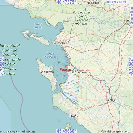
Fouras GPS coordinates[2]
45° 59' 14.496" North, 1° 5' 33.9" West
| Map corner | latitude | longitude |
|---|---|---|
| Upper-left | 46.47375°, | -1.79588° |
| Center: | 45.98736°, | -1.09275° |
| Lower-right: | 45.49666°, | -0.38962° |
| Map W x H: | 108.6×108.6 km | = 67.5×67.5mi |
| max Lat: | 51.07786° ⇑66.4% North |
| Fouras: | 45.98736° |
| min Lat: | ⇓33.6% South 41.3874° |
| min Long | Fouras | max Long |
| -5.08615° | -1.09275° | 9.52242° |
| W 10.9%⇐ | ⇒89.1% E |
Elevation
Elevation of Fouras is 13 m = 43 ft, and this is 180.7 m = 593 ft below average elevation for this country.
| Max E: |
2333 m = 7654 ft | 96.3% |
| Avg. | 193.7 m = 635 ft | |
| Fouras | 13 m = 43 ft | |
Min E: |
-1 m = -3 ft | 3.7% |
See also: France elevation on elevation.city.
Geographical zone
Fouras is located in North temperate zone (between Tropic of Cancer and the Arctic Circle). Distance of this North polar circle is 2287.9 km =1421.6 mi to North.| Distance of | km | miles | from Fouras |
|---|---|---|---|
| North Pole | 4893.7 | 3040.8 | to North |
| Arctic Circle | 2287.9 | 1421.6 | to North |
| Tropic Cancer | 2507.4 | 1558 | to South |
| Equator | 5113.3 | 3177.3 | to South |


Nearby cities:
15 places around Fouras: (largest is in red/bold)
• Angoulins
13.2 km =8.2 mi,  355°
355°
• Boyard-Ville
11.8 km =7.3 mi,  259°
259°
• Breuil-Magné
10.3 km =6.4 mi,  91°
91°
• Châtelaillon-Plage
9.4 km =5.8 mi,  1°
1°
• Moëze
10.3 km =6.4 mi,  154°
154°
• Port-des-Barques
4.6 km =2.9 mi,  165°
165°
• Rochefort
11 km =6.8 mi,  117°
117°
• Saint-Laurent-de-la-Prée
4.4 km =2.7 mi,  96°
96°
• Saint-Nazaire-sur-Charente
6.5 km =4 mi, 150°
• Saint-Vivien
10.7 km =6.6 mi,  16°
16°
• Salles-sur-Mer
13.4 km =8.3 mi,  11°
11°
• Soubise
9.6 km =6 mi,  137°
137°
• Thairé
11.8 km =7.3 mi,  36°
36°
• Vergeroux
8.8 km =5.5 mi,  105°
105°
• Yves
4.9 km =3 mi, 44°
Sources, notices
• [Note1] Compared only with cities in France existing in our database
• [Src1] Map data: © OpenStreetMap contributors (CC-BY-SA)
• [Src2] Other city data from geonames.org with taken over terms of usage.
• [Src3] Geographical zone / Annual Mean Temperature by Robert A. Rohde @ Wikipedia
