Wissembourg geodata
Wissembourg (Grand Est) is a seat of a third-order administrative division; located in France in Europe/Paris (GMT+2) time zone. With population of 8,800 people, there are 1092 cities with bigger population in this country. Compared to other cities in France, 80.6% of cities are located further ↓South; 99.4% of cities are located further ←West and 58% of cities have lower elevation than Wissembourg. Note1
Administrative division(s):
- Level 1: Grand Est
- Level 2: Bas-Rhin
- Level 3: Arrondissement de Haguenau-Wissembourg
- Level 4: Wissembourg


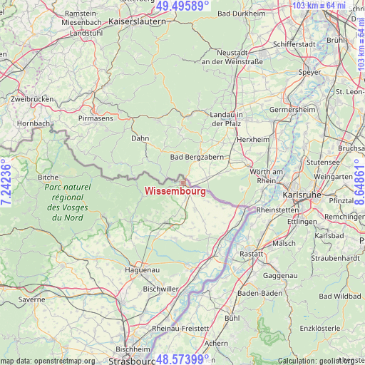
Wissembourg GPS coordinates[2]
49° 2' 13.488" North, 7° 56' 43.728" East
| Map corner | latitude | longitude |
|---|---|---|
| Upper-left | 49.49589°, | 7.24236° |
| Center: | 49.03708°, | 7.94548° |
| Lower-right: | 48.57399°, | 8.64861° |
| Map W x H: | 102.5×102.5 km | = 63.7×63.7mi |
| max Lat: | 51.07786° ⇑19.4% North |
| Wissembourg: | 49.03708° |
| min Lat: | ⇓80.6% South 41.3874° |
| min Long | Wissembourg | max Long |
| -5.08615° | 7.94548° | 9.52242° |
| W 99.4%⇐ | ⇒0.59999999999999% E |
Elevation
Elevation of Wissembourg is 161 m = 528 ft, and this is 32.7 m = 107 ft below average elevation for this country.
| Max E: |
2333 m = 7654 ft | 42% |
| Avg. | 193.7 m = 635 ft | |
| Wissembourg | 161 m = 528 ft | |
Min E: |
-1 m = -3 ft | 58% |
See also: France elevation on elevation.city.
Geographical zone
Wissembourg is located in North temperate zone (between Tropic of Cancer and the Arctic Circle). Distance of this North polar circle is 1948.8 km =1210.9 mi to North.| Distance of | km | miles | from Wissembourg |
|---|---|---|---|
| North Pole | 4554.6 | 2830.1 | to North |
| Arctic Circle | 1948.8 | 1210.9 | to North |
| Tropic Cancer | 2846.5 | 1768.7 | to South |
| Equator | 5452.4 | 3388 | to South |


Nearby cities:
15 places around Wissembourg: (largest is in red/bold)
• Betschdorf
15.8 km =9.8 mi,  191°
191°
• Birlenbach
8.2 km =5.1 mi,  215°
215°
• Climbach
7.2 km =4.5 mi,  253°
253°
• Gœrsdorf
16.2 km =10.1 mi,  233°
233°
• Hatten
15.3 km =9.5 mi,  170°
170°
• Kutzenhausen
13.3 km =8.3 mi,  210°
210°
• Lampertsloch
13 km =8.1 mi, 227°
• Langensoultzbach
17.2 km =10.7 mi,  243°
243°
• Lauterbourg
18.3 km =11.4 mi,  112°
112°
• Lembach
11.9 km =7.4 mi, 251°
• Lobsann
11 km =6.8 mi, 221°
• Merkwiller-Pechelbronn
14 km =8.7 mi, 217°
• Preuschdorf
14.7 km =9.1 mi, 225°
• Soultz-sous-Forêts
12.1 km =7.5 mi,  202°
202°
• Surbourg
15.8 km =9.8 mi, 206°
Sources, notices
• [Note1] Compared only with cities in France existing in our database
• [Src1] Map data: © OpenStreetMap contributors (CC-BY-SA)
• [Src2] Other city data from geonames.org with taken over terms of usage.
• [Src3] Geographical zone / Annual Mean Temperature by Robert A. Rohde @ Wikipedia
