Wingersheim geodata
Wingersheim (Grand Est) is a populated place; located in France in Europe/Paris (GMT+2) time zone. With population of 1,119 people, there are 8016 cities with bigger population in this country. Compared to other cities in France, 73.7% of cities are located further ↓South; 98.7% of cities are located further ←West and 64.9% of cities have lower elevation than Wingersheim. Note1
Administrative division(s):
- Level 1: Grand Est
- Level 2: Bas-Rhin
- Level 3: Arrondissement de Saverne
- Level 4: Wingersheim les Quatre Bans


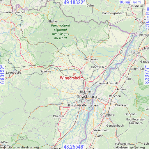
Wingersheim GPS coordinates[2]
48° 43' 17.364" North, 7° 38' 4.704" East
| Map corner | latitude | longitude |
|---|---|---|
| Upper-left | 49.18322°, | 6.93152° |
| Center: | 48.72149°, | 7.63464° |
| Lower-right: | 48.25548°, | 8.33777° |
| Map W x H: | 103.2×103.2 km | = 64.1×64.1mi |
| max Lat: | 51.07786° ⇑26.3% North |
| Wingersheim: | 48.72149° |
| min Lat: | ⇓73.7% South 41.3874° |
| min Long | Wingersheim | max Long |
| -5.08615° | 7.63464° | 9.52242° |
| W 98.7%⇐ | ⇒1.3% E |
Elevation
Elevation of Wingersheim is 193 m = 633 ft, and this is 0.69999999999999 m = 2 ft below average elevation for this country.
| Max E: |
2333 m = 7654 ft | 35.1% |
| Avg. | 193.7 m = 635 ft | |
| Wingersheim | 193 m = 633 ft | |
Min E: |
-1 m = -3 ft | 64.9% |
See also: France elevation on elevation.city.
Geographical zone
Wingersheim is located in North temperate zone (between Tropic of Cancer and the Arctic Circle). Distance of this North polar circle is 1983.9 km =1232.7 mi to North.| Distance of | km | miles | from Wingersheim |
|---|---|---|---|
| North Pole | 4589.7 | 2851.9 | to North |
| Arctic Circle | 1983.9 | 1232.7 | to North |
| Tropic Cancer | 2811.4 | 1746.9 | to South |
| Equator | 5417.3 | 3366.2 | to South |


Nearby cities:
15 places around Wingersheim: (largest is in red/bold)
• Bernolsheim
5.5 km =3.4 mi,  46°
46°
• Berstett
5 km =3.1 mi,  160°
160°
• Brumath
5.8 km =3.6 mi,  76°
76°
• Durningen
6.5 km =4 mi,  228°
228°
• Eckwersheim
6.4 km =4 mi,  134°
134°
• Hochfelden
6.3 km =3.9 mi,  309°
309°
• Kienheim
5.3 km =3.3 mi, 228°
• Mittelhausen
1.4 km =0.9 mi,  194°
194°
• Mommenheim
4.1 km =2.5 mi,  10°
10°
• Olwisheim
4 km =2.5 mi, 132°
• Pfettisheim
6.9 km =4.3 mi,  173°
173°
• Schwindratzheim
4.6 km =2.9 mi,  325°
325°
• Truchtersheim
6.8 km =4.2 mi,  197°
197°
• Waltenheim-sur-Zorn
2.9 km =1.8 mi,  351°
351°
• Wittersheim
6.9 km =4.3 mi, 14°
Sources, notices
• [Note1] Compared only with cities in France existing in our database
• [Src1] Map data: © OpenStreetMap contributors (CC-BY-SA)
• [Src2] Other city data from geonames.org with taken over terms of usage.
• [Src3] Geographical zone / Annual Mean Temperature by Robert A. Rohde @ Wikipedia
