Waltenheim-sur-Zorn geodata
Waltenheim-sur-Zorn (Grand Est) is a populated place; located in France in Europe/Paris (GMT+2) time zone. With population of 673 people, there are 12171 cities with bigger population in this country. Compared to other cities in France, 74.2% of cities are located further ↓South; 98.7% of cities are located further ←West and 55% of cities have lower elevation than Waltenheim-sur-Zorn. Note1
Administrative division(s):
- Level 1: Grand Est
- Level 2: Bas-Rhin
- Level 3: Arrondissement de Saverne
- Level 4: Waltenheim-sur-Zorn


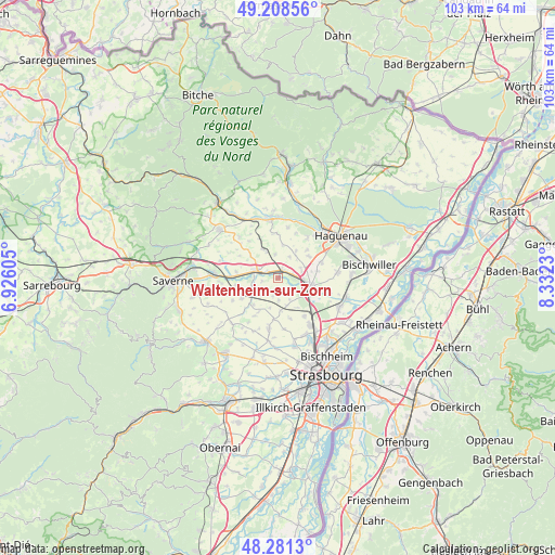
Waltenheim-sur-Zorn GPS coordinates[2]
48° 44' 49.452" North, 7° 37' 45.048" East
| Map corner | latitude | longitude |
|---|---|---|
| Upper-left | 49.20856°, | 6.92605° |
| Center: | 48.74707°, | 7.62918° |
| Lower-right: | 48.2813°, | 8.3323° |
| Map W x H: | 103.1×103.1 km | = 64.1×64.1mi |
| max Lat: | 51.07786° ⇑25.8% North |
| Waltenheim-sur-Zorn: | 48.74707° |
| min Lat: | ⇓74.2% South 41.3874° |
| min Long | Waltenheim-sur- | max Long |
| -5.08615° | 7.62918° | 9.52242° |
| W 98.7%⇐ | ⇒1.3% E |
Elevation
Elevation of Waltenheim-sur-Zorn is 150 m = 492 ft, and this is 43.7 m = 143 ft below average elevation for this country.
| Max E: |
2333 m = 7654 ft | 45% |
| Avg. | 193.7 m = 635 ft | |
| Waltenheim-sur-Zorn | 150 m = 492 ft | |
Min E: |
-1 m = -3 ft | 55% |
See also: France elevation on elevation.city.
Geographical zone
Waltenheim-sur-Zorn is located in North temperate zone (between Tropic of Cancer and the Arctic Circle). Distance of this North polar circle is 1981 km =1230.9 mi to North.| Distance of | km | miles | from Waltenheim-sur-Zorn |
|---|---|---|---|
| North Pole | 4586.9 | 2850.2 | to North |
| Arctic Circle | 1981 | 1230.9 | to North |
| Tropic Cancer | 2814.2 | 1748.7 | to South |
| Equator | 5420.2 | 3368 | to South |


Nearby cities:
15 places around Waltenheim-sur-Zorn: (largest is in red/bold)
• Alteckendorf
5.5 km =3.4 mi,  334°
334°
• Batzendorf
6.9 km =4.3 mi,  54°
54°
• Bernolsheim
4.5 km =2.8 mi,  77°
77°
• Brumath
6.2 km =3.9 mi,  103°
103°
• Hochfelden
4.7 km =2.9 mi,  284°
284°
• Kienheim
7.3 km =4.5 mi,  209°
209°
• Kriegsheim
7.4 km =4.6 mi, 80°
• Minversheim
4.3 km =2.7 mi,  352°
352°
• Mittelhausen
4.2 km =2.6 mi,  179°
179°
• Mommenheim
1.7 km =1.1 mi,  44°
44°
• Olwisheim
6.5 km =4 mi,  149°
149°
• Schwindratzheim
2.4 km =1.5 mi,  293°
293°
• Wingersheim
2.9 km =1.8 mi,  171°
171°
• Wintershouse
7.3 km =4.5 mi, 46°
• Wittersheim
4.4 km =2.7 mi,  28°
28°
Sources, notices
• [Note1] Compared only with cities in France existing in our database
• [Src1] Map data: © OpenStreetMap contributors (CC-BY-SA)
• [Src2] Other city data from geonames.org with taken over terms of usage.
• [Src3] Geographical zone / Annual Mean Temperature by Robert A. Rohde @ Wikipedia
