Hochfelden geodata
Hochfelden (Grand Est) is a populated place; located in France in Europe/Paris (GMT+2) time zone. With population of 3,120 people, there are 3125 cities with bigger population in this country. Compared to other cities in France, 74.5% of cities are located further ↓South; 98.4% of cities are located further ←West and 60.9% of cities have lower elevation than Hochfelden. Note1
Administrative division(s):
- Level 1: Grand Est
- Level 2: Bas-Rhin
- Level 3: Arrondissement de Saverne
- Level 4: Hochfelden


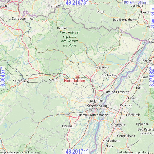
Hochfelden GPS coordinates[2]
48° 45' 26.568" North, 7° 34' 3.684" East
| Map corner | latitude | longitude |
|---|---|---|
| Upper-left | 49.21878°, | 6.86457° |
| Center: | 48.75738°, | 7.56769° |
| Lower-right: | 48.29171°, | 8.27082° |
| Map W x H: | 103.1×103.1 km | = 64.1×64.1mi |
| max Lat: | 51.07786° ⇑25.5% North |
| Hochfelden: | 48.75738° |
| min Lat: | ⇓74.5% South 41.3874° |
| min Long | Hochfelden | max Long |
| -5.08615° | 7.56769° | 9.52242° |
| W 98.4%⇐ | ⇒1.6% E |
Elevation
Elevation of Hochfelden is 174 m = 571 ft, and this is 19.7 m = 65 ft below average elevation for this country.
| Max E: |
2333 m = 7654 ft | 39.1% |
| Avg. | 193.7 m = 635 ft | |
| Hochfelden | 174 m = 571 ft | |
Min E: |
-1 m = -3 ft | 60.9% |
See also: France elevation on elevation.city.
Geographical zone
Hochfelden is located in North temperate zone (between Tropic of Cancer and the Arctic Circle). Distance of this North polar circle is 1979.9 km =1230.3 mi to North.| Distance of | km | miles | from Hochfelden |
|---|---|---|---|
| North Pole | 4585.7 | 2849.4 | to North |
| Arctic Circle | 1979.9 | 1230.3 | to North |
| Tropic Cancer | 2815.4 | 1749.4 | to South |
| Equator | 5421.3 | 3368.6 | to South |


Nearby cities:
15 places around Hochfelden: (largest is in red/bold)
• Alteckendorf
4.4 km =2.7 mi,  29°
29°
• Bosselshausen
6.8 km =4.2 mi,  321°
321°
• Duntzenheim
5.6 km =3.5 mi,  204°
204°
• Ettendorf
6.3 km =3.9 mi,  9°
9°
• Lupstein
6.4 km =4 mi,  249°
249°
• Melsheim
3.3 km =2.1 mi,  269°
269°
• Minversheim
5 km =3.1 mi,  51°
51°
• Mittelhausen
7 km =4.3 mi,  139°
139°
• Mommenheim
5.7 km =3.5 mi,  89°
89°
• Saessolsheim
6.8 km =4.2 mi,  216°
216°
• Schwindratzheim
2.3 km =1.4 mi, 94°
• Waltenheim-sur-Zorn
4.7 km =2.9 mi,  104°
104°
• Wilwisheim
4.6 km =2.9 mi,  257°
257°
• Wingersheim
6.3 km =3.9 mi,  129°
129°
• Wittersheim
7.2 km =4.5 mi,  67°
67°
Sources, notices
• [Note1] Compared only with cities in France existing in our database
• [Src1] Map data: © OpenStreetMap contributors (CC-BY-SA)
• [Src2] Other city data from geonames.org with taken over terms of usage.
• [Src3] Geographical zone / Annual Mean Temperature by Robert A. Rohde @ Wikipedia
