Wignehies geodata
Wignehies (Hauts-de-France) is a populated place; located in France in Europe/Paris (GMT+2) time zone. With population of 3,386 people, there are 2874 cities with bigger population in this country. Compared to other cities in France, 93.7% of cities are located further ↓South; 67.9% of cities are located further ←West and 60.7% of cities have lower elevation than Wignehies. Note1
Administrative division(s):
- Level 1: Hauts-de-France
- Level 2: Nord
- Level 3: Avesnes-sur-Helpe
- Level 4: Wignehies


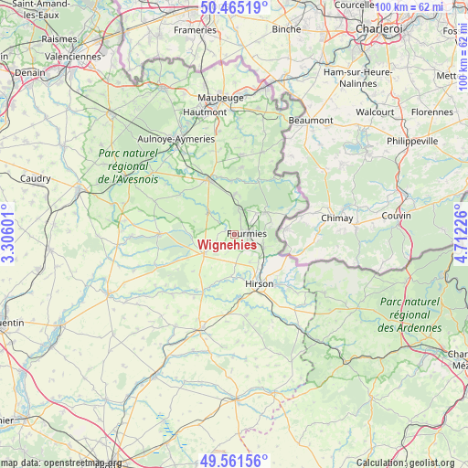
Wignehies GPS coordinates[2]
50° 0' 55.8" North, 4° 0' 32.868" East
| Map corner | latitude | longitude |
|---|---|---|
| Upper-left | 50.46519°, | 3.30601° |
| Center: | 50.0155°, | 4.00913° |
| Lower-right: | 49.56156°, | 4.71226° |
| Map W x H: | 100.5×100.5 km | = 62.4×62.4mi |
| max Lat: | 51.07786° ⇑6.3% North |
| Wignehies: | 50.0155° |
| min Lat: | ⇓93.7% South 41.3874° |
| min Long | Wignehies | max Long |
| -5.08615° | 4.00913° | 9.52242° |
| W 67.9%⇐ | ⇒32.1% E |
Elevation
Elevation of Wignehies is 173 m = 568 ft, and this is 20.7 m = 68 ft below average elevation for this country.
| Max E: |
2333 m = 7654 ft | 39.3% |
| Avg. | 193.7 m = 635 ft | |
| Wignehies | 173 m = 568 ft | |
Min E: |
-1 m = -3 ft | 60.7% |
See also: France elevation on elevation.city.
Geographical zone
Wignehies is located in North temperate zone (between Tropic of Cancer and the Arctic Circle). Distance of this North polar circle is 1840 km =1143.3 mi to North.| Distance of | km | miles | from Wignehies |
|---|---|---|---|
| North Pole | 4445.9 | 2762.6 | to North |
| Arctic Circle | 1840 | 1143.3 | to North |
| Tropic Cancer | 2955.3 | 1836.3 | to South |
| Equator | 5561.2 | 3455.6 | to South |


Nearby cities:
15 places around Wignehies: (largest is in red/bold)
• Anor
7.1 km =4.4 mi,  113°
113°
• Avesnelles
12.2 km =7.6 mi,  338°
338°
• Avesnes-sur-Helpe
13.4 km =8.3 mi,  333°
333°
• Buire
12.9 km =8 mi,  165°
165°
• Buironfosse
13.5 km =8.4 mi,  246°
246°
• Clairfontaine
3.8 km =2.4 mi,  200°
200°
• Floyon
9.2 km =5.7 mi,  288°
288°
• Fourmies
2.8 km =1.7 mi,  90°
90°
• Hirson
11.6 km =7.2 mi,  153°
153°
• La Capelle
8.6 km =5.3 mi,  230°
230°
• La Flamengrie
6.5 km =4 mi,  256°
256°
• Mondrepuis
6.6 km =4.1 mi, 150°
• Neuve-Maison
9.6 km =6 mi, 169°
• Sains-du-Nord
8.7 km =5.4 mi,  359°
359°
• Trélon
8.1 km =5 mi,  54°
54°
Sources, notices
• [Note1] Compared only with cities in France existing in our database
• [Src1] Map data: © OpenStreetMap contributors (CC-BY-SA)
• [Src2] Other city data from geonames.org with taken over terms of usage.
• [Src3] Geographical zone / Annual Mean Temperature by Robert A. Rohde @ Wikipedia
