Wavrin geodata
Wavrin (Hauts-de-France) is a populated place; located in France in Europe/Paris (GMT+2) time zone. With population of 7,770 people, there are 1245 cities with bigger population in this country. Compared to other cities in France, 97.9% of cities are located further ↓South; 56.9% of cities are located further ←West and 91.2% of cities have higher elevation than Wavrin. Note1
Administrative division(s):
- Level 1: Hauts-de-France
- Level 2: Nord
- Level 3: Arrondissement de Lille
- Level 4: Wavrin


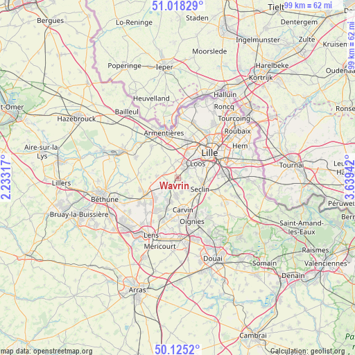
Wavrin GPS coordinates[2]
50° 34' 25.896" North, 2° 56' 10.68" East
| Map corner | latitude | longitude |
|---|---|---|
| Upper-left | 51.01829°, | 2.23317° |
| Center: | 50.57386°, | 2.9363° |
| Lower-right: | 50.1252°, | 3.63942° |
| Map W x H: | 99.3×99.3 km | = 61.7×61.7mi |
| max Lat: | 51.07786° ⇑2.1% North |
| Wavrin: | 50.57386° |
| min Lat: | ⇓97.9% South 41.3874° |
| min Long | Wavrin | max Long |
| -5.08615° | 2.9363° | 9.52242° |
| W 56.9%⇐ | ⇒43.1% E |
Elevation
Elevation of Wavrin is 27 m = 89 ft, and this is 166.7 m = 547 ft below average elevation for this country.
| Max E: |
2333 m = 7654 ft | 91.2% |
| Avg. | 193.7 m = 635 ft | |
| Wavrin | 27 m = 89 ft | |
Min E: |
-1 m = -3 ft | 8.8% |
See also: France elevation on elevation.city.
Geographical zone
Wavrin is located in North temperate zone (between Tropic of Cancer and the Arctic Circle). Distance of this North polar circle is 1777.9 km =1104.7 mi to North.| Distance of | km | miles | from Wavrin |
|---|---|---|---|
| North Pole | 4383.8 | 2724 | to North |
| Arctic Circle | 1777.9 | 1104.7 | to North |
| Tropic Cancer | 3017.4 | 1874.9 | to South |
| Equator | 5623.3 | 3494.2 | to South |


Nearby cities:
15 places around Wavrin: (largest is in red/bold)
• Allennes-les-Marais
4.2 km =2.6 mi,  163°
163°
• Annoeullin
5 km =3.1 mi,  183°
183°
• Beaucamps-Ligny
3.8 km =2.4 mi,  337°
337°
• Don
3 km =1.9 mi,  204°
204°
• Emmerin
5.1 km =3.2 mi,  63°
63°
• Fournes-en-Weppes
3.6 km =2.2 mi,  289°
289°
• Gondecourt
4.7 km =2.9 mi,  134°
134°
• Hallennes-lez-Haubourdin
5.2 km =3.2 mi,  24°
24°
• Haubourdin
5.5 km =3.4 mi,  45°
45°
• Houplin-Ancoisne
4.8 km =3 mi,  104°
104°
• Marquillies
5.1 km =3.2 mi,  246°
246°
• Noyelles-lès-Seclin
5.7 km =3.5 mi,  87°
87°
• Radinghem-en-Weppes
5.4 km =3.4 mi, 339°
• Sainghin-en-Weppes
2.9 km =1.8 mi, 248°
• Santes
2.9 km =1.8 mi,  41°
41°
Sources, notices
• [Note1] Compared only with cities in France existing in our database
• [Src1] Map data: © OpenStreetMap contributors (CC-BY-SA)
• [Src2] Other city data from geonames.org with taken over terms of usage.
• [Src3] Geographical zone / Annual Mean Temperature by Robert A. Rohde @ Wikipedia
