Beaucamps-Ligny geodata
Beaucamps-Ligny (Hauts-de-France) is a populated place; located in France in Europe/Paris (GMT+2) time zone. With population of 979 people, there are 8991 cities with bigger population in this country. Compared to other cities in France, 98.1% of cities are located further ↓South; 56.6% of cities are located further ←West and 88.3% of cities have higher elevation than Beaucamps-Ligny. Note1
Administrative division(s):
- Level 1: Hauts-de-France
- Level 2: Nord
- Level 3: Arrondissement de Lille
- Level 4: Beaucamps-Ligny


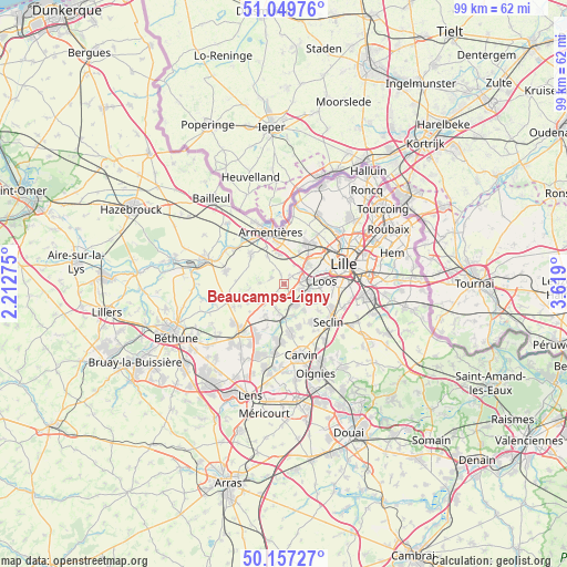
Beaucamps-Ligny GPS coordinates[2]
50° 36' 20.268" North, 2° 54' 57.168" East
| Map corner | latitude | longitude |
|---|---|---|
| Upper-left | 51.04976°, | 2.21275° |
| Center: | 50.60563°, | 2.91588° |
| Lower-right: | 50.15727°, | 3.619° |
| Map W x H: | 99.2×99.2 km | = 61.6×61.6mi |
| max Lat: | 51.07786° ⇑1.9% North |
| Beaucamps-Ligny: | 50.60563° |
| min Lat: | ⇓98.1% South 41.3874° |
| min Long | Beaucamps-Ligny | max Long |
| -5.08615° | 2.91588° | 9.52242° |
| W 56.6%⇐ | ⇒43.4% E |
Elevation
Elevation of Beaucamps-Ligny is 34 m = 112 ft, and this is 159.7 m = 524 ft below average elevation for this country.
| Max E: |
2333 m = 7654 ft | 88.3% |
| Avg. | 193.7 m = 635 ft | |
| Beaucamps-Ligny | 34 m = 112 ft | |
Min E: |
-1 m = -3 ft | 11.7% |
See also: France elevation on elevation.city.
Geographical zone
Beaucamps-Ligny is located in North temperate zone (between Tropic of Cancer and the Arctic Circle). Distance of this North polar circle is 1774.4 km =1102.6 mi to North.| Distance of | km | miles | from Beaucamps-Ligny |
|---|---|---|---|
| North Pole | 4380.2 | 2721.7 | to North |
| Arctic Circle | 1774.4 | 1102.6 | to North |
| Tropic Cancer | 3020.9 | 1877.1 | to South |
| Equator | 5626.8 | 3496.3 | to South |


Nearby cities:
15 places around Beaucamps-Ligny: (largest is in red/bold)
• Bois-Grenier
5.7 km =3.5 mi,  329°
329°
• Capinghem
5.5 km =3.4 mi,  36°
36°
• Englos
3.7 km =2.3 mi,  51°
51°
• Ennetières-en-Weppes
3.7 km =2.3 mi,  27°
27°
• Fournes-en-Weppes
3 km =1.9 mi,  220°
220°
• Fromelles
4.4 km =2.7 mi,  272°
272°
• Hallennes-lez-Haubourdin
3.8 km =2.4 mi,  71°
71°
• Haubourdin
5.3 km =3.3 mi,  86°
86°
• Herlies
5.4 km =3.4 mi,  234°
234°
• Le Maisnil
2.4 km =1.5 mi,  296°
296°
• Radinghem-en-Weppes
1.5 km =0.9 mi,  342°
342°
• Sainghin-en-Weppes
4.8 km =3 mi,  195°
195°
• Santes
3.6 km =2.2 mi,  112°
112°
• Sequedin
5.2 km =3.2 mi,  64°
64°
• Wavrin
3.8 km =2.4 mi,  157°
157°
Sources, notices
• [Note1] Compared only with cities in France existing in our database
• [Src1] Map data: © OpenStreetMap contributors (CC-BY-SA)
• [Src2] Other city data from geonames.org with taken over terms of usage.
• [Src3] Geographical zone / Annual Mean Temperature by Robert A. Rohde @ Wikipedia
