Santes geodata
Santes (Hauts-de-France) is a populated place; located in France in Europe/Paris (GMT+2) time zone. With population of 5,069 people, there are 1947 cities with bigger population in this country. Compared to other cities in France, 98% of cities are located further ↓South; 57.3% of cities are located further ←West and 93.9% of cities have higher elevation than Santes. Note1
Administrative division(s):
- Level 1: Hauts-de-France
- Level 2: Nord
- Level 3: Arrondissement de Lille
- Level 4: Santes


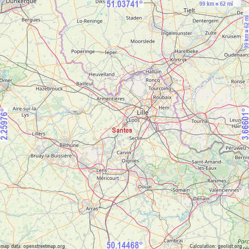
Santes GPS coordinates[2]
50° 35' 35.376" North, 2° 57' 46.404" East
| Map corner | latitude | longitude |
|---|---|---|
| Upper-left | 51.03741°, | 2.25976° |
| Center: | 50.59316°, | 2.96289° |
| Lower-right: | 50.14468°, | 3.66601° |
| Map W x H: | 99.3×99.3 km | = 61.7×61.7mi |
| max Lat: | 51.07786° ⇑2% North |
| Santes: | 50.59316° |
| min Lat: | ⇓98% South 41.3874° |
| min Long | Santes | max Long |
| -5.08615° | 2.96289° | 9.52242° |
| W 57.3%⇐ | ⇒42.7% E |
Elevation
Elevation of Santes is 20 m = 66 ft, and this is 173.7 m = 570 ft below average elevation for this country.
| Max E: |
2333 m = 7654 ft | 93.9% |
| Avg. | 193.7 m = 635 ft | |
| Santes | 20 m = 66 ft | |
Min E: |
-1 m = -3 ft | 6.1% |
See also: France elevation on elevation.city.
Geographical zone
Santes is located in North temperate zone (between Tropic of Cancer and the Arctic Circle). Distance of this North polar circle is 1775.7 km =1103.4 mi to North.| Distance of | km | miles | from Santes |
|---|---|---|---|
| North Pole | 4381.6 | 2722.6 | to North |
| Arctic Circle | 1775.7 | 1103.4 | to North |
| Tropic Cancer | 3019.5 | 1876.2 | to South |
| Equator | 5625.4 | 3495.5 | to South |


Nearby cities:
15 places around Santes: (largest is in red/bold)
• Beaucamps-Ligny
3.6 km =2.2 mi,  292°
292°
• Emmerin
2.7 km =1.7 mi,  86°
86°
• Englos
3.7 km =2.3 mi,  353°
353°
• Ennetières-en-Weppes
5 km =3.1 mi,  341°
341°
• Fournes-en-Weppes
5.4 km =3.4 mi,  260°
260°
• Gondecourt
5.6 km =3.5 mi,  164°
164°
• Hallennes-lez-Haubourdin
2.6 km =1.6 mi,  5°
5°
• Haubourdin
2.6 km =1.6 mi,  50°
50°
• Houplin-Ancoisne
4.4 km =2.7 mi,  140°
140°
• Loos
4.4 km =2.7 mi,  64°
64°
• Noyelles-lès-Seclin
4.3 km =2.7 mi,  115°
115°
• Radinghem-en-Weppes
4.7 km =2.9 mi,  307°
307°
• Sainghin-en-Weppes
5.6 km =3.5 mi,  234°
234°
• Sequedin
3.9 km =2.4 mi,  21°
21°
• Wavrin
2.9 km =1.8 mi,  221°
221°
Sources, notices
• [Note1] Compared only with cities in France existing in our database
• [Src1] Map data: © OpenStreetMap contributors (CC-BY-SA)
• [Src2] Other city data from geonames.org with taken over terms of usage.
• [Src3] Geographical zone / Annual Mean Temperature by Robert A. Rohde @ Wikipedia
