Vy-lès-Lure geodata
Vy-lès-Lure (Bourgogne-Franche-Comté) is a populated place; located in France in Europe/Paris (GMT+2) time zone. With population of 561 people, there are 13985 cities with bigger population in this country. Compared to other cities in France, 53.4% of cities are located further ↓South; 91.4% of cities are located further ←West and 80% of cities have lower elevation than Vy-lès-Lure. Note1
Administrative division(s):
- Level 1: Bourgogne-Franche-Comté
- Level 2: Département de la Haute-Saône
- Level 3: Arrondissement de Lure
- Level 4: Vy-lès-Lure


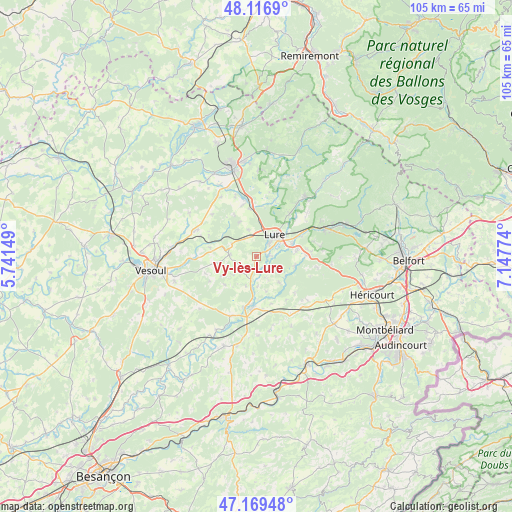
Vy-lès-Lure GPS coordinates[2]
47° 38' 43.224" North, 6° 26' 40.632" East
| Map corner | latitude | longitude |
|---|---|---|
| Upper-left | 48.1169°, | 5.74149° |
| Center: | 47.64534°, | 6.44462° |
| Lower-right: | 47.16948°, | 7.14774° |
| Map W x H: | 105.3×105.3 km | = 65.4×65.4mi |
| max Lat: | 51.07786° ⇑46.6% North |
| Vy-lès-Lure: | 47.64534° |
| min Lat: | ⇓53.4% South 41.3874° |
| min Long | Vy-lès-Lure | max Long |
| -5.08615° | 6.44462° | 9.52242° |
| W 91.4%⇐ | ⇒8.6% E |
Elevation
Elevation of Vy-lès-Lure is 290 m = 951 ft, and this is 96.3 m = 316 ft above average elevation for this country.
| Max E: |
2333 m = 7654 ft | 20% |
| Vy-lès-Lure | 290 m 951 ft | |
| Avg. | 193.7 m = 635 ft | |
Min E: |
-1 m = -3 ft | 80% |
See also: France elevation on elevation.city.
Geographical zone
Vy-lès-Lure is located in North temperate zone (between Tropic of Cancer and the Arctic Circle). Distance of this North polar circle is 2103.5 km =1307.1 mi to North.| Distance of | km | miles | from Vy-lès-Lure |
|---|---|---|---|
| North Pole | 4709.4 | 2926.3 | to North |
| Arctic Circle | 2103.5 | 1307.1 | to North |
| Tropic Cancer | 2691.7 | 1672.5 | to South |
| Equator | 5297.7 | 3291.8 | to South |


Nearby cities:
15 places around Vy-lès-Lure: (largest is in red/bold)
• Athesans-Étroitefontaine
7.4 km =4.6 mi,  133°
133°
• Citers
11.1 km =6.9 mi,  346°
346°
• Esprels
13.3 km =8.3 mi,  203°
203°
• Frotey-lès-Lure
8.2 km =5.1 mi,  82°
82°
• La Côte
10.6 km =6.6 mi,  64°
64°
• Lure
5.7 km =3.5 mi,  42°
42°
• Magny-Vernois
3.6 km =2.2 mi, 40°
• Moffans-et-Vacheresse
8.2 km =5.1 mi,  102°
102°
• Mélisey
15.6 km =9.7 mi, 40°
• Ronchamp
15.6 km =9.7 mi,  66°
66°
• Roye
7.7 km =4.8 mi, 69°
• Saint-Barthélemy
15.6 km =9.7 mi, 41°
• Saint-Germain
11 km =6.8 mi, 36°
• Saulx
13.5 km =8.4 mi,  296°
296°
• Villersexel
10.6 km =6.6 mi,  184°
184°
Sources, notices
• [Note1] Compared only with cities in France existing in our database
• [Src1] Map data: © OpenStreetMap contributors (CC-BY-SA)
• [Src2] Other city data from geonames.org with taken over terms of usage.
• [Src3] Geographical zone / Annual Mean Temperature by Robert A. Rohde @ Wikipedia
