Saint-Barthélemy geodata
Saint-Barthélemy (Bourgogne-Franche-Comté) is a populated place; located in France in Europe/Paris (GMT+2) time zone. With population of 926 people, there are 9423 cities with bigger population in this country. Compared to other cities in France, 55% of cities are located further ↓South; 92.3% of cities are located further ←West and 83.8% of cities have lower elevation than Saint-Barthélemy. Note1
Administrative division(s):
- Level 1: Bourgogne-Franche-Comté
- Level 2: Département de la Haute-Saône
- Level 3: Arrondissement de Lure
- Level 4: Saint-Barthélemy


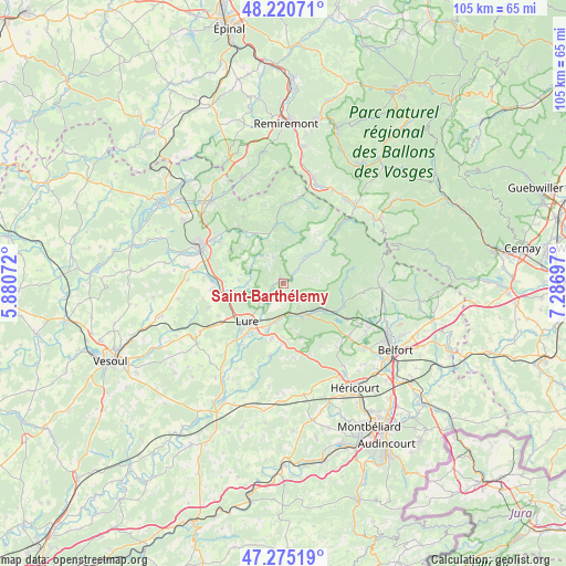
Saint-Barthélemy GPS coordinates[2]
47° 45' 0.36" North, 6° 35' 1.824" East
| Map corner | latitude | longitude |
|---|---|---|
| Upper-left | 48.22071°, | 5.88072° |
| Center: | 47.7501°, | 6.58384° |
| Lower-right: | 47.27519°, | 7.28697° |
| Map W x H: | 105.1×105.1 km | = 65.3×65.3mi |
| max Lat: | 51.07786° ⇑45% North |
| Saint-Barthélemy: | 47.7501° |
| min Lat: | ⇓55% South 41.3874° |
| min Long | Saint-Barthéle | max Long |
| -5.08615° | 6.58384° | 9.52242° |
| W 92.3%⇐ | ⇒7.7% E |
Elevation
Elevation of Saint-Barthélemy is 332 m = 1089 ft, and this is 138.3 m = 454 ft above average elevation for this country.
| Max E: |
2333 m = 7654 ft | 16.2% |
| Saint-Barthélemy | 332 m 1089 ft | |
| Avg. | 193.7 m = 635 ft | |
Min E: |
-1 m = -3 ft | 83.8% |
See also: France elevation on elevation.city.
Geographical zone
Saint-Barthélemy is located in North temperate zone (between Tropic of Cancer and the Arctic Circle). Distance of this North polar circle is 2091.9 km =1299.8 mi to North.| Distance of | km | miles | from Saint-Barthélemy |
|---|---|---|---|
| North Pole | 4697.7 | 2919 | to North |
| Arctic Circle | 2091.9 | 1299.8 | to North |
| Tropic Cancer | 2703.4 | 1679.8 | to South |
| Equator | 5309.3 | 3299 | to South |


Nearby cities:
15 places around Saint-Barthélemy: (largest is in red/bold)
• Champagney
8.9 km =5.5 mi,  124°
124°
• Faucogney-et-la-Mer
10.3 km =6.4 mi,  351°
351°
• Fresse
3.9 km =2.4 mi,  69°
69°
• Frotey-lès-Lure
10.8 km =6.7 mi,  192°
192°
• La Côte
7.1 km =4.4 mi, 186°
• Lure
9.9 km =6.2 mi,  221°
221°
• Magny-Vernois
12 km =7.5 mi, 222°
• Mélisey
0.4 km =0.2 mi,  311°
311°
• Plancher-Bas
11.5 km =7.1 mi,  107°
107°
• Plancher-les-Mines
12 km =7.5 mi,  83°
83°
• Ronchamp
6.7 km =4.2 mi,  144°
144°
• Roye
9.5 km =5.9 mi,  199°
199°
• Saint-Germain
4.8 km =3 mi,  234°
234°
• Servance
10.3 km =6.4 mi,  46°
46°
• Ternuay-Melay-et-Saint-Hilaire
5.4 km =3.4 mi,  42°
42°
Sources, notices
• [Note1] Compared only with cities in France existing in our database
• [Src1] Map data: © OpenStreetMap contributors (CC-BY-SA)
• [Src2] Other city data from geonames.org with taken over terms of usage.
• [Src3] Geographical zone / Annual Mean Temperature by Robert A. Rohde @ Wikipedia
