Voreppe geodata
Voreppe (Auvergne-Rhône-Alpes) is a populated place; located in France in Europe/Paris (GMT+2) time zone. With population of 10,214 people, there are 928 cities with bigger population in this country. Compared to other cities in France, 76.4% of cities are located further ↑North; 83.9% of cities are located further ←West and 72.8% of cities have lower elevation than Voreppe. Note1
Administrative division(s):
- Level 1: Auvergne-Rhône-Alpes
- Level 2: Département de l'Isère
- Level 3: Arrondissement de Grenoble
- Level 4: Voreppe


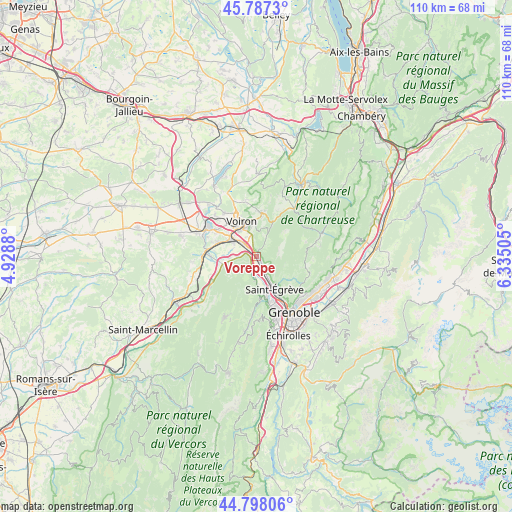
Voreppe GPS coordinates[2]
45° 17' 41.424" North, 5° 37' 54.912" East
| Map corner | latitude | longitude |
|---|---|---|
| Upper-left | 45.7873°, | 4.9288° |
| Center: | 45.29484°, | 5.63192° |
| Lower-right: | 44.79806°, | 6.33505° |
| Map W x H: | 110×110 km | = 68.4×68.4mi |
| max Lat: | 51.07786° ⇑76.4% North |
| Voreppe: | 45.29484° |
| min Lat: | ⇓23.6% South 41.3874° |
| min Long | Voreppe | max Long |
| -5.08615° | 5.63192° | 9.52242° |
| W 83.9%⇐ | ⇒16.1% E |
Elevation
Elevation of Voreppe is 235 m = 771 ft, and this is 41.3 m = 135 ft above average elevation for this country.
| Max E: |
2333 m = 7654 ft | 27.2% |
| Voreppe | 235 m 771 ft | |
| Avg. | 193.7 m = 635 ft | |
Min E: |
-1 m = -3 ft | 72.8% |
See also: France elevation on elevation.city.
Geographical zone
Voreppe is located in North temperate zone (between Tropic of Cancer and the Arctic Circle). Distance of this North polar circle is 2364.9 km =1469.5 mi to North.| Distance of | km | miles | from Voreppe |
|---|---|---|---|
| North Pole | 4970.7 | 3088.6 | to North |
| Arctic Circle | 2364.9 | 1469.5 | to North |
| Tropic Cancer | 2430.4 | 1510.2 | to South |
| Equator | 5036.3 | 3129.4 | to South |


Nearby cities:
15 places around Voreppe: (largest is in red/bold)
• Coublevie
7.3 km =4.5 mi,  347°
347°
• Fontanil-Cornillon
5.3 km =3.3 mi,  152°
152°
• La Buisse
5.9 km =3.7 mi, 346°
• Moirans
7.3 km =4.5 mi,  303°
303°
• Montaud
6.6 km =4.1 mi,  237°
237°
• Noyarey
5.6 km =3.5 mi,  178°
178°
• Pommiers-la-Placette
3.3 km =2.1 mi,  35°
35°
• Proveysieux
6.4 km =4 mi,  126°
126°
• Quaix-en-Chartreuse
8.3 km =5.2 mi, 126°
• Saint-Jean-de-Moirans
6.7 km =4.2 mi,  326°
326°
• Saint-Quentin-sur-Isère
7.1 km =4.4 mi,  255°
255°
• Saint-Égrève
7.9 km =4.9 mi, 150°
• Veurey-Voroize
2.8 km =1.7 mi,  210°
210°
• Voiron
8.6 km =5.3 mi,  335°
335°
• Vourey
9.3 km =5.8 mi,  288°
288°
Sources, notices
• [Note1] Compared only with cities in France existing in our database
• [Src1] Map data: © OpenStreetMap contributors (CC-BY-SA)
• [Src2] Other city data from geonames.org with taken over terms of usage.
• [Src3] Geographical zone / Annual Mean Temperature by Robert A. Rohde @ Wikipedia
